You are here: Home > Network List > TA - USArray Transportable Network (new EarthScope stations) Stations List
> Station N59A State Game Land 141, Hazleton, PA, USA > Earthquake Result Viewer
N59A State Game Land 141, Hazleton, PA, USA - Earthquake Result Viewer
| Earthquake location: |
Near Coast Of Nicaragua |
| Earthquake latitude/longitude: |
12.4/-87.6 |
| Earthquake time(UTC): |
2011/07/03 (184) 06:34:39 GMT |
| Earthquake Depth: |
59 km |
| Earthquake Magnitude: |
5.5 MB, 5.8 MW, 5.7 MW |
| Earthquake Catalog/Contributor: |
WHDF/NEIC |
|
| Network: |
TA USArray Transportable Network (new EarthScope stations) |
| Station: |
N59A State Game Land 141, Hazleton, PA, USA |
| Lat/Lon: |
40.92 N/75.77 W |
| Elevation: |
508 m |
|
| Distance: |
30.2 deg |
| Az: |
17.947 deg |
| Baz: |
203.405 deg |
| Ray Param: |
0.079304405 |
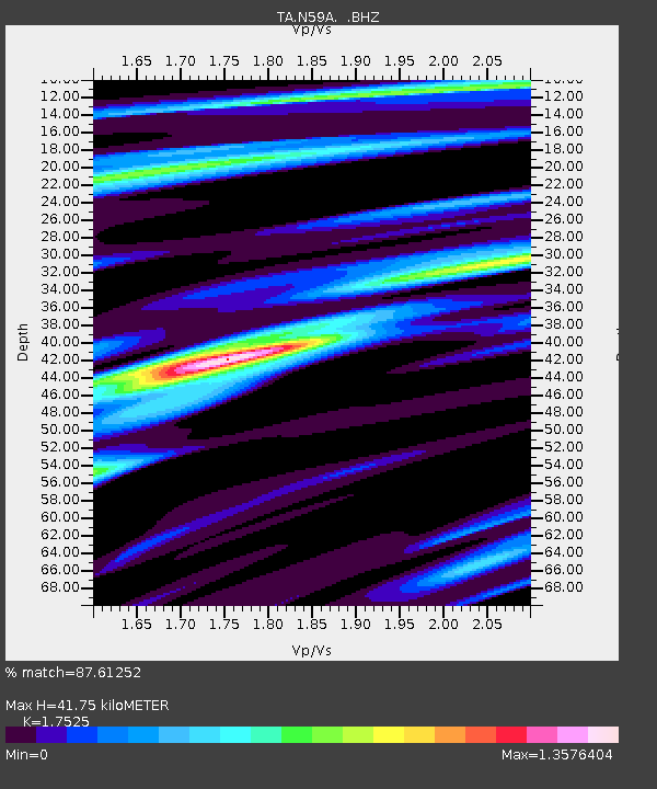
| Estimated Moho Depth: |
41.75 km |
| Estimated Crust Vp/Vs: |
1.75 |
| Assumed Crust Vp: |
6.283 km/s |
| Estimated Crust Vs: |
3.585 km/s |
| Estimated Crust Poisson's Ratio: |
0.26 |
|
| Radial Match: |
87.61252 % |
| Radial Bump: |
381 |
| Transverse Match: |
66.33199 % |
| Transverse Bump: |
400 |
| SOD ConfigId: |
395004 |
| Insert Time: |
2011-12-10 05:05:29.080 +0000 |
| GWidth: |
2.5 |
| Max Bumps: |
400 |
| Tol: |
0.001 |
|
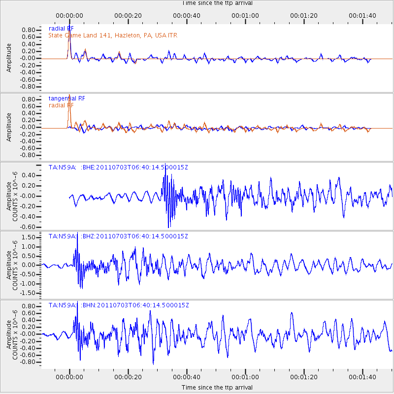
Signal To Noise
| Channel | StoN | STA | LTA |
| TA:N59A: :BHZ:20110703T06:40:14.500015Z | 8.058963 | 5.5145176E-7 | 6.842714E-8 |
| TA:N59A: :BHN:20110703T06:40:14.500015Z | 6.755709 | 2.9833117E-7 | 4.4159858E-8 |
| TA:N59A: :BHE:20110703T06:40:14.500015Z | 4.486169 | 2.425089E-7 | 5.405701E-8 |
| Arrivals |
| Ps | 5.4 SECOND |
| PpPs | 17 SECOND |
| PsPs/PpSs | 22 SECOND |


