You are here: Home > Network List > TA - USArray Transportable Network (new EarthScope stations) Stations List
> Station J04D Umpqua National Forest, Toketee, OR, USA > Earthquake Result Viewer
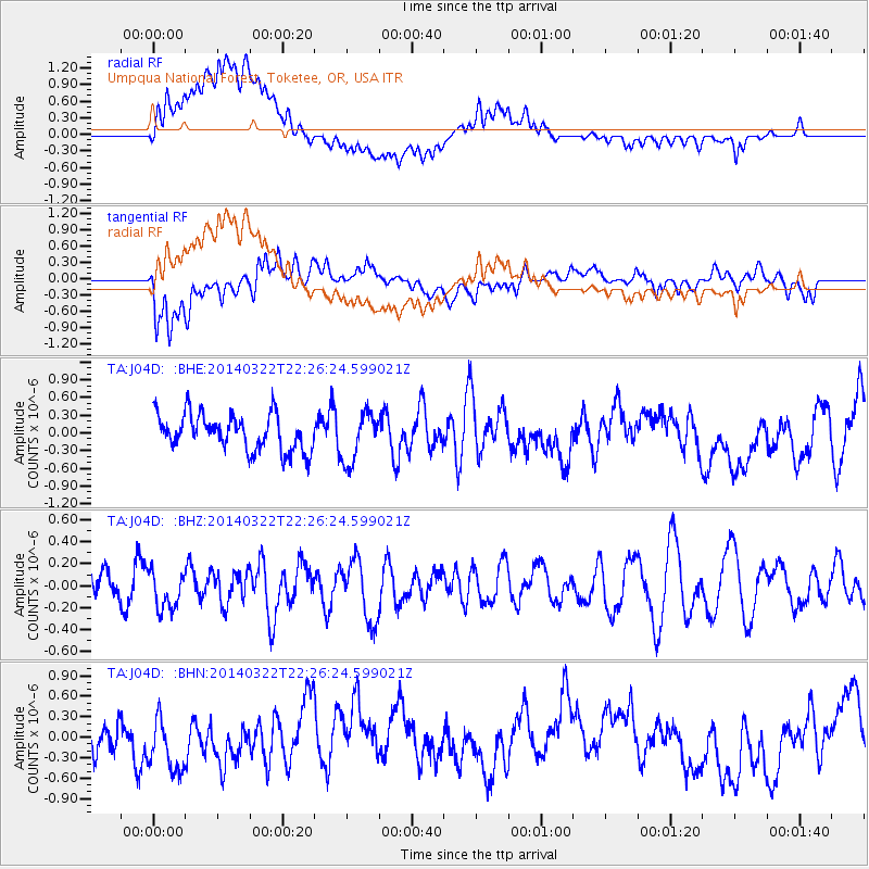
J04D Umpqua National Forest, Toketee, OR, USA - Earthquake Result Viewer
*The percent match for this event was below the threshold and hence no stack was calculated.
| Earthquake location: |
Near Coast Of Northern Chile |
| Earthquake latitude/longitude: |
-19.7/-71.0 |
| Earthquake time(UTC): |
2014/03/22 (081) 22:14:57 GMT |
| Earthquake Depth: |
19 km |
| Earthquake Magnitude: |
5.1 MW |
| Earthquake Catalog/Contributor: |
ISC/ISC |
|
| Network: |
TA USArray Transportable Network (new EarthScope stations) |
| Station: |
J04D Umpqua National Forest, Toketee, OR, USA |
| Lat/Lon: |
43.24 N/122.11 W |
| Elevation: |
1948 m |
|
| Distance: |
78.3 deg |
| Az: |
324.485 deg |
| Baz: |
131.509 deg |
| Ray Param: |
$rayparam |
*The percent match for this event was below the threshold and hence was not used in the summary stack. |
|
| Radial Match: |
52.838062 % |
| Radial Bump: |
400 |
| Transverse Match: |
59.144623 % |
| Transverse Bump: |
400 |
| SOD ConfigId: |
3390531 |
| Insert Time: |
2019-04-10 20:28:44.322 +0000 |
| GWidth: |
2.5 |
| Max Bumps: |
400 |
| Tol: |
0.001 |
|
Signal To Noise
| Channel | StoN | STA | LTA |
| TA:J04D: :BHZ:20140322T22:26:24.599021Z | 1.2194762 | 1.7213281E-7 | 1.4115307E-7 |
| TA:J04D: :BHN:20140322T22:26:24.599021Z | 1.5919976 | 4.4187598E-7 | 2.775607E-7 |
| TA:J04D: :BHE:20140322T22:26:24.599021Z | 1.3741447 | 4.1895782E-7 | 3.0488627E-7 |
| Arrivals |
| Ps | |
| PpPs | |
| PsPs/PpSs | |


