You are here: Home > Network List > BK - Berkeley Digital Seismograph Network Stations List
> Station CMB Columbia College, Columbia, CA > Earthquake Result Viewer
CMB Columbia College, Columbia, CA - Earthquake Result Viewer

| Earthquake location: |
Kermadec Islands Region |
| Earthquake latitude/longitude: |
-29.5/-176.3 |
| Earthquake time(UTC): |
2011/07/06 (187) 19:03:18 GMT |
| Earthquake Depth: |
17 km |
| Earthquake Magnitude: |
7.0 MB, 7.8 MS, 7.6 MW, 7.6 MW |
| Earthquake Catalog/Contributor: |
WHDF/NEIC |
|
| Network: |
BK Berkeley Digital Seismograph Network |
| Station: |
CMB Columbia College, Columbia, CA |
| Lat/Lon: |
38.03 N/120.39 W |
| Elevation: |
697 m |
|
| Distance: |
85.2 deg |
| Az: |
41.043 deg |
| Baz: |
226.439 deg |
| Ray Param: |
0.0449485 |
| Estimated Moho Depth: |
16.75 km |
| Estimated Crust Vp/Vs: |
1.61 |
| Assumed Crust Vp: |
6.597 km/s |
| Estimated Crust Vs: |
4.104 km/s |
| Estimated Crust Poisson's Ratio: |
0.18 |
|
| Radial Match: |
95.60001 % |
| Radial Bump: |
348 |
| Transverse Match: |
84.554146 % |
| Transverse Bump: |
400 |
| SOD ConfigId: |
395004 |
| Insert Time: |
2011-12-10 05:22:16.574 +0000 |
| GWidth: |
2.5 |
| Max Bumps: |
400 |
| Tol: |
0.001 |
|
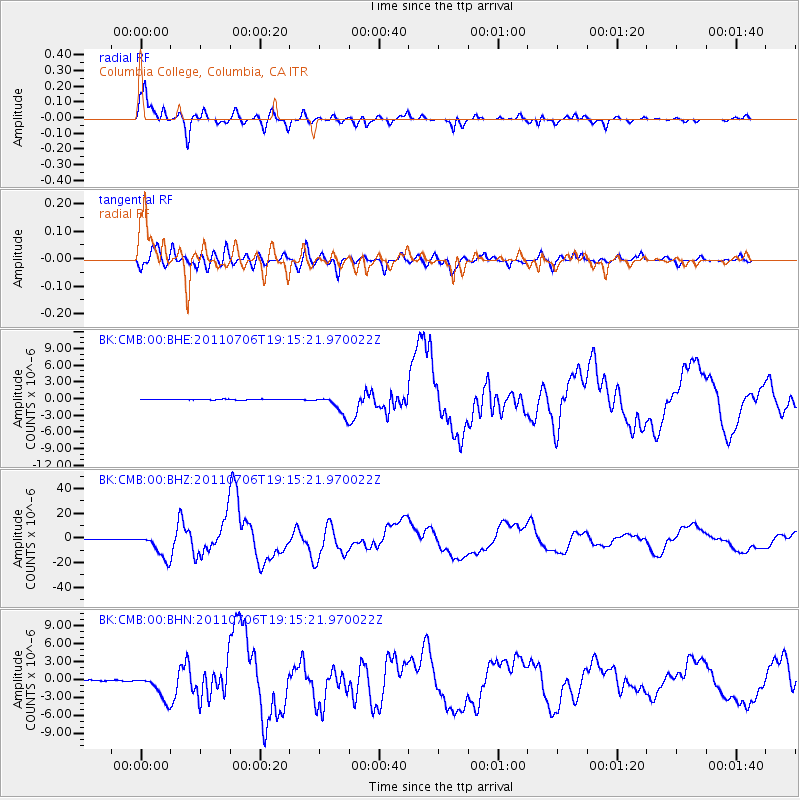
Signal To Noise
| Channel | StoN | STA | LTA |
| BK:CMB:00:BHZ:20110706T19:15:21.970022Z | 89.47015 | 1.0323538E-5 | 1.15385276E-7 |
| BK:CMB:00:BHN:20110706T19:15:21.970022Z | 29.309206 | 2.155472E-6 | 7.354249E-8 |
| BK:CMB:00:BHE:20110706T19:15:21.970022Z | 29.026506 | 1.8018471E-6 | 6.207593E-8 |
| Arrivals |
| Ps | 1.6 SECOND |
| PpPs | 6.4 SECOND |
| PsPs/PpSs | 8.0 SECOND |


