You are here: Home > Network List > CI - Caltech Regional Seismic Network Stations List
> Station SLA SLA, Trona, CA, USA > Earthquake Result Viewer
SLA SLA, Trona, CA, USA - Earthquake Result Viewer
| Earthquake location: |
Kermadec Islands Region |
| Earthquake latitude/longitude: |
-29.5/-176.3 |
| Earthquake time(UTC): |
2011/07/06 (187) 19:03:18 GMT |
| Earthquake Depth: |
17 km |
| Earthquake Magnitude: |
7.0 MB, 7.8 MS, 7.6 MW, 7.6 MW |
| Earthquake Catalog/Contributor: |
WHDF/NEIC |
|
| Network: |
CI Caltech Regional Seismic Network |
| Station: |
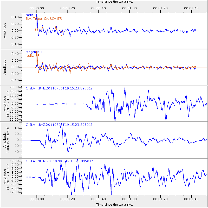
SLA SLA, Trona, CA, USA |
| Lat/Lon: |
35.89 N/117.28 W |
| Elevation: |
1174 m |
|
| Distance: |
85.6 deg |
| Az: |
44.31 deg |
| Baz: |
228.562 deg |
| Ray Param: |
0.04467024 |
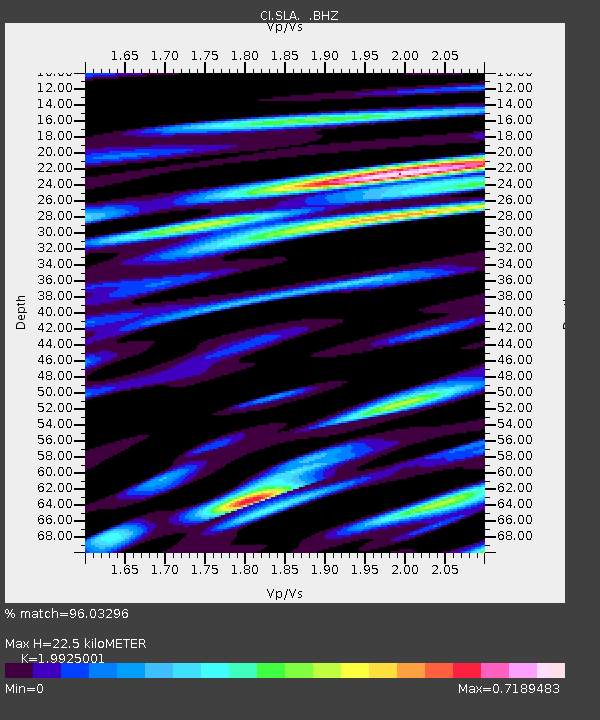
| Estimated Moho Depth: |
22.5 km |
| Estimated Crust Vp/Vs: |
1.99 |
| Assumed Crust Vp: |
6.276 km/s |
| Estimated Crust Vs: |
3.15 km/s |
| Estimated Crust Poisson's Ratio: |
0.33 |
|
| Radial Match: |
96.03296 % |
| Radial Bump: |
400 |
| Transverse Match: |
93.034676 % |
| Transverse Bump: |
400 |
| SOD ConfigId: |
395004 |
| Insert Time: |
2011-12-10 05:25:01.810 +0000 |
| GWidth: |
2.5 |
| Max Bumps: |
400 |
| Tol: |
0.001 |
|
Signal To Noise
| Channel | StoN | STA | LTA |
| CI:SLA: :BHZ:20110706T19:15:23.89501Z | 91.267845 | 9.112039E-6 | 9.983844E-8 |
| CI:SLA: :BHN:20110706T19:15:23.89501Z | 9.104255 | 1.4876265E-6 | 1.6339904E-7 |
| CI:SLA: :BHE:20110706T19:15:23.89501Z | 11.371063 | 2.7240217E-6 | 2.3955732E-7 |
| Arrivals |
| Ps | 3.6 SECOND |
| PpPs | 11 SECOND |
| PsPs/PpSs | 14 SECOND |


