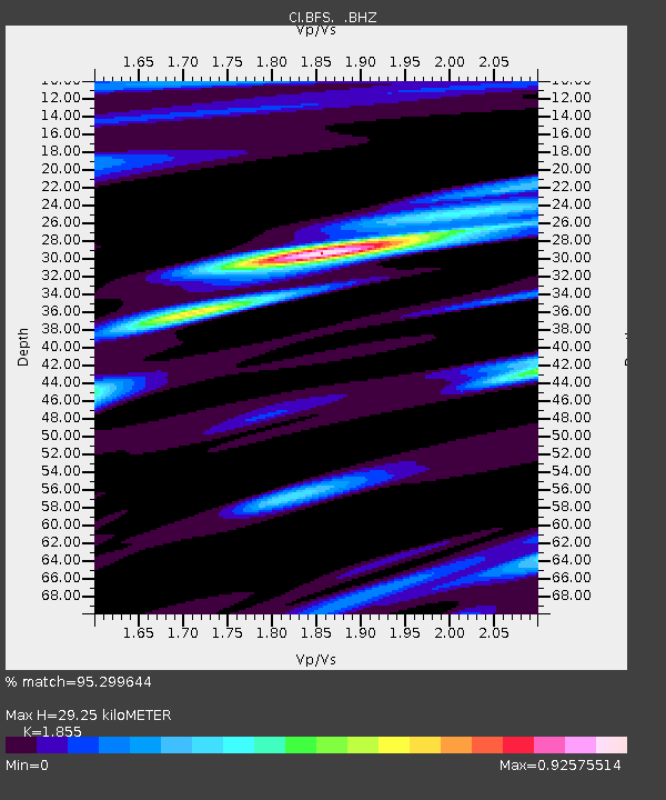
BFS Mt Baldy Forest Station - Earthquake Result Viewer
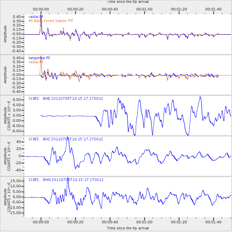
Earthquake location: Kermadec Islands Region
Earthquake latitude/longitude: -29.5/-176.3
Earthquake time(UTC): 2011/07/06 (187) 19:03:18 GMT
Earthquake Depth: 17 km
Earthquake Magnitude: 7.0 MB, 7.8 MS, 7.6 MW, 7.6 MW
Earthquake Catalog/Contributor: WHDF/NEIC
Network: CI Caltech Regional Seismic Network
Station: BFS Mt Baldy Forest Station
Lat/Lon: 34.24 N/117.66 W
Elevation: 1312 m
Distance: 84.2 deg
Az: 45.344 deg
Baz: 228.439 deg
Ray Param: 0.04561857
Estimated Moho Depth: 29.25 km
Estimated Crust Vp/Vs: 1.86
Assumed Crust Vp: 6.276 km/s
Estimated Crust Vs: 3.383 km/s
Estimated Crust Poisson's Ratio: 0.30
Radial Match: 95.299644 %
Radial Bump: 335
Transverse Match: 77.55978 %
Transverse Bump: 400
SOD ConfigId: 395004
Insert Time: 2011-12-10 05:26:17.556 +0000
GWidth: 2.5
Max Bumps: 400
Tol: 0.001

Signal To Noise

ChannelStoNSTALTA
CI:BFS: :BHZ:20110706T19:15:17.27001Z85.278281.0195675E-51.1955768E-7
CI:BFS: :BHN:20110706T19:15:17.27001Z23.113762.4593776E-61.0640318E-7
CI:BFS: :BHE:20110706T19:15:17.27001Z21.952272.474445E-61.1271932E-7
Arrivals
Ps4.1 SECOND
PpPs13 SECOND
PsPs/PpSs17 SECOND