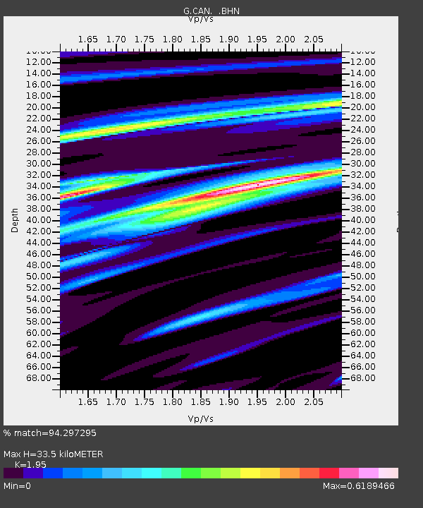
CAN Canberra, Australia - Earthquake Result Viewer

Earthquake location: Irian Jaya Region, Indonesia
Earthquake latitude/longitude: -4.0/135.0
Earthquake time(UTC): 2004/02/07 (038) 02:42:35 GMT
Earthquake Depth: 10 km
Earthquake Magnitude: 6.2 MB, 7.5 MS, 7.3 MW, 7.3 MW
Earthquake Catalog/Contributor: WHDF/NEIC
Network: G GEOSCOPE
Station: CAN Canberra, Australia
Lat/Lon: 35.32 S/149.00 E
Elevation: 650 m
Distance: 33.7 deg
Az: 159.172 deg
Baz: 334.294 deg
Ray Param: 0.0780675
Estimated Moho Depth: 33.5 km
Estimated Crust Vp/Vs: 1.95
Assumed Crust Vp: 6.633 km/s
Estimated Crust Vs: 3.402 km/s
Estimated Crust Poisson's Ratio: 0.32
Radial Match: 94.297295 %
Radial Bump: 285
Transverse Match: 66.05846 %
Transverse Bump: 400
SOD ConfigId: 2459
Insert Time: 2010-02-26 21:36:01.930 +0000
GWidth: 2.5
Max Bumps: 400
Tol: 0.001

Signal To Noise

ChannelStoNSTALTA
G:CAN: :BHN:20040207T02:48:46.048989Z1.47360444.402071E-62.9872817E-6
G:CAN: :BHE:20040207T02:48:46.048989Z1.8424012.2476877E-61.2199774E-6
G:CAN: :BHZ:20040207T02:48:46.048989Z1.40327547.1436175E-65.090674E-6
Arrivals
Ps5.2 SECOND
PpPs14 SECOND
PsPs/PpSs19 SECOND