You are here: Home > Network List > TA - USArray Transportable Network (new EarthScope stations) Stations List
> Station V33A Lossen Ranch, Watonga, OK, USA > Earthquake Result Viewer
V33A Lossen Ranch, Watonga, OK, USA - Earthquake Result Viewer
| Earthquake location: |
Kermadec Islands Region |
| Earthquake latitude/longitude: |
-29.5/-176.3 |
| Earthquake time(UTC): |
2011/07/06 (187) 19:03:18 GMT |
| Earthquake Depth: |
17 km |
| Earthquake Magnitude: |
7.0 MB, 7.8 MS, 7.6 MW, 7.6 MW |
| Earthquake Catalog/Contributor: |
WHDF/NEIC |
|
| Network: |
TA USArray Transportable Network (new EarthScope stations) |
| Station: |
V33A Lossen Ranch, Watonga, OK, USA |
| Lat/Lon: |
35.82 N/98.29 W |
| Elevation: |
420 m |
|
| Distance: |
98.0 deg |
| Az: |
53.41 deg |
| Baz: |
239.423 deg |
| Ray Param: |
0.040035248 |
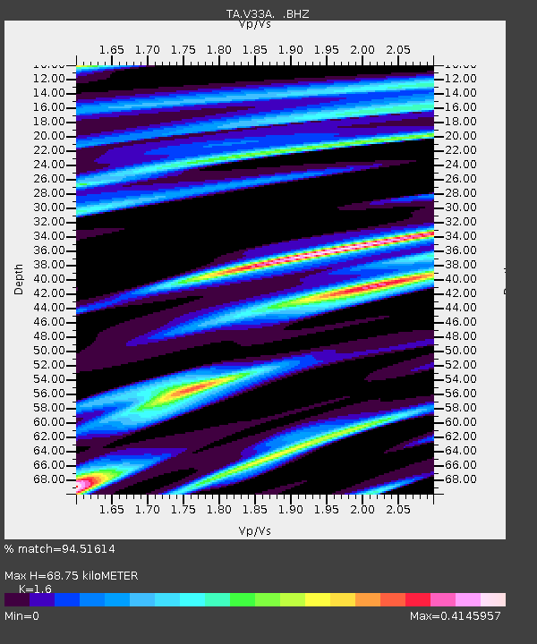
| Estimated Moho Depth: |
68.75 km |
| Estimated Crust Vp/Vs: |
1.60 |
| Assumed Crust Vp: |
6.315 km/s |
| Estimated Crust Vs: |
3.947 km/s |
| Estimated Crust Poisson's Ratio: |
0.18 |
|
| Radial Match: |
94.51614 % |
| Radial Bump: |
400 |
| Transverse Match: |
72.584076 % |
| Transverse Bump: |
400 |
| SOD ConfigId: |
395004 |
| Insert Time: |
2011-12-10 05:34:28.873 +0000 |
| GWidth: |
2.5 |
| Max Bumps: |
400 |
| Tol: |
0.001 |
|

Signal To Noise
| Channel | StoN | STA | LTA |
| TA:V33A: :BHZ:20110706T19:16:21.62499Z | 12.07367 | 3.690899E-6 | 3.0569817E-7 |
| TA:V33A: :BHN:20110706T19:16:21.62499Z | 1.5575057 | 4.375306E-7 | 2.8091748E-7 |
| TA:V33A: :BHE:20110706T19:16:21.62499Z | 2.5388355 | 8.5448136E-7 | 3.3656428E-7 |
| Arrivals |
| Ps | 6.7 SECOND |
| PpPs | 28 SECOND |
| PsPs/PpSs | 34 SECOND |


