You are here: Home > Network List > TA - USArray Transportable Network (new EarthScope stations) Stations List
> Station L02D Cave Junction, OR, USA > Earthquake Result Viewer
L02D Cave Junction, OR, USA - Earthquake Result Viewer
| Earthquake location: |
Kermadec Islands Region |
| Earthquake latitude/longitude: |
-29.5/-176.3 |
| Earthquake time(UTC): |
2011/07/06 (187) 19:03:18 GMT |
| Earthquake Depth: |
17 km |
| Earthquake Magnitude: |
7.0 MB, 7.8 MS, 7.6 MW, 7.6 MW |
| Earthquake Catalog/Contributor: |
WHDF/NEIC |
|
| Network: |
TA USArray Transportable Network (new EarthScope stations) |
| Station: |
L02D Cave Junction, OR, USA |
| Lat/Lon: |
42.16 N/123.60 W |
| Elevation: |
458 m |
|
| Distance: |
86.3 deg |
| Az: |
36.369 deg |
| Baz: |
224.026 deg |
| Ray Param: |
0.0441291 |
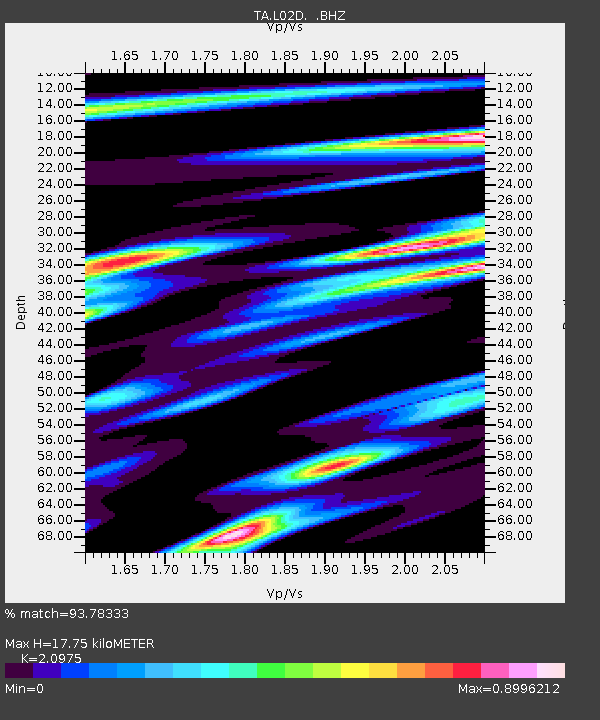
| Estimated Moho Depth: |
17.75 km |
| Estimated Crust Vp/Vs: |
2.10 |
| Assumed Crust Vp: |
6.522 km/s |
| Estimated Crust Vs: |
3.109 km/s |
| Estimated Crust Poisson's Ratio: |
0.35 |
|
| Radial Match: |
93.78333 % |
| Radial Bump: |
400 |
| Transverse Match: |
86.55641 % |
| Transverse Bump: |
400 |
| SOD ConfigId: |
395004 |
| Insert Time: |
2011-12-10 05:35:32.258 +0000 |
| GWidth: |
2.5 |
| Max Bumps: |
400 |
| Tol: |
0.001 |
|
Signal To Noise
| Channel | StoN | STA | LTA |
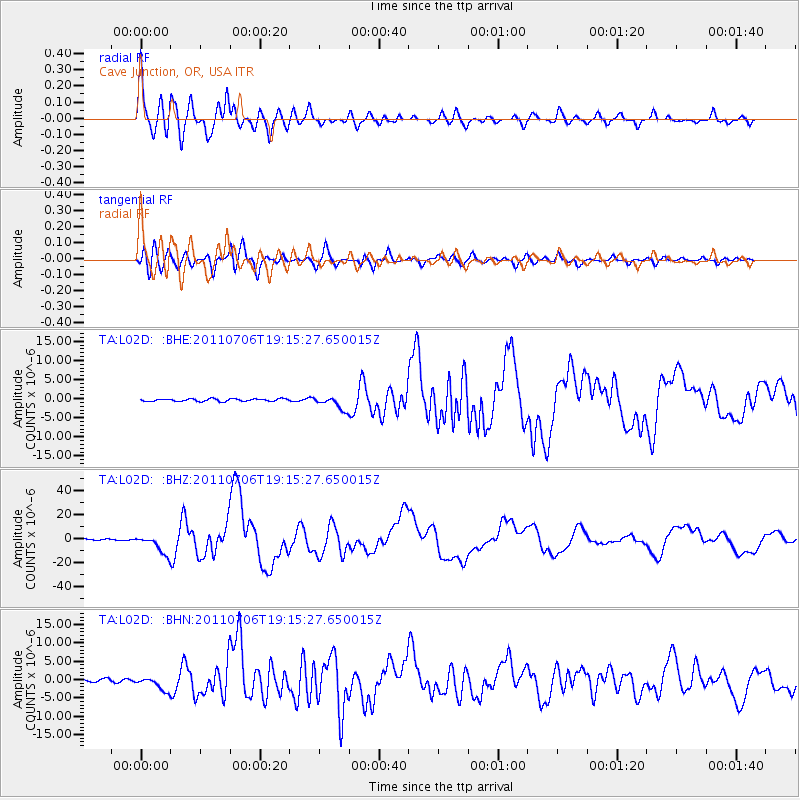
| TA:L02D: :BHZ:20110706T19:15:27.650015Z | 23.403437 | 7.924673E-6 | 3.3861153E-7 |
| TA:L02D: :BHN:20110706T19:15:27.650015Z | 8.097032 | 1.9249314E-6 | 2.3773298E-7 |
| TA:L02D: :BHE:20110706T19:15:27.650015Z | 5.1252995 | 1.7161786E-6 | 3.3484457E-7 |
| Arrivals |
| Ps | 3.0 SECOND |
| PpPs | 8.3 SECOND |
| PsPs/PpSs | 11 SECOND |


