You are here: Home > Network List > TA - USArray Transportable Network (new EarthScope stations) Stations List
> Station 734A La Parita Creek, Jourdanton, TX, USA > Earthquake Result Viewer
734A La Parita Creek, Jourdanton, TX, USA - Earthquake Result Viewer
| Earthquake location: |
Kermadec Islands Region |
| Earthquake latitude/longitude: |
-29.5/-176.3 |
| Earthquake time(UTC): |
2011/07/06 (187) 19:03:18 GMT |
| Earthquake Depth: |
17 km |
| Earthquake Magnitude: |
7.0 MB, 7.8 MS, 7.6 MW, 7.6 MW |
| Earthquake Catalog/Contributor: |
WHDF/NEIC |
|
| Network: |
TA USArray Transportable Network (new EarthScope stations) |
| Station: |
734A La Parita Creek, Jourdanton, TX, USA |
| Lat/Lon: |
28.85 N/98.56 W |
| Elevation: |
121 m |
|
| Distance: |
94.2 deg |
| Az: |
59.287 deg |
| Baz: |
238.651 deg |
| Ray Param: |
0.04108994 |
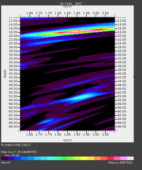
| Estimated Moho Depth: |
17.25 km |
| Estimated Crust Vp/Vs: |
1.91 |
| Assumed Crust Vp: |
6.347 km/s |
| Estimated Crust Vs: |
3.319 km/s |
| Estimated Crust Poisson's Ratio: |
0.31 |
|
| Radial Match: |
96.33813 % |
| Radial Bump: |
261 |
| Transverse Match: |
89.50061 % |
| Transverse Bump: |
400 |
| SOD ConfigId: |
395004 |
| Insert Time: |
2011-12-10 05:36:42.702 +0000 |
| GWidth: |
2.5 |
| Max Bumps: |
400 |
| Tol: |
0.001 |
|

Signal To Noise
| Channel | StoN | STA | LTA |
| TA:734A: :BHZ:20110706T19:16:04.600027Z | 31.790102 | 5.4029188E-6 | 1.6995601E-7 |
| TA:734A: :BHN:20110706T19:16:04.600027Z | 1.7656435 | 5.8912286E-7 | 3.3365902E-7 |
| TA:734A: :BHE:20110706T19:16:04.600027Z | 4.4851837 | 1.2518651E-6 | 2.7911122E-7 |
| Arrivals |
| Ps | 2.5 SECOND |
| PpPs | 7.8 SECOND |
| PsPs/PpSs | 10 SECOND |


