You are here: Home > Network List > TA - USArray Transportable Network (new EarthScope stations) Stations List
> Station 337A Centerville, TX, USA > Earthquake Result Viewer
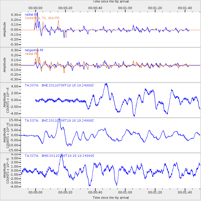
337A Centerville, TX, USA - Earthquake Result Viewer
*The percent match for this event was below the threshold and hence no stack was calculated.
| Earthquake location: |
Kermadec Islands Region |
| Earthquake latitude/longitude: |
-29.5/-176.3 |
| Earthquake time(UTC): |
2011/07/06 (187) 19:03:18 GMT |
| Earthquake Depth: |
17 km |
| Earthquake Magnitude: |
7.0 MB, 7.8 MS, 7.6 MW, 7.6 MW |
| Earthquake Catalog/Contributor: |
WHDF/NEIC |
|
| Network: |
TA USArray Transportable Network (new EarthScope stations) |
| Station: |
337A Centerville, TX, USA |
| Lat/Lon: |
31.32 N/95.89 W |
| Elevation: |
150 m |
|
| Distance: |
97.5 deg |
| Az: |
58.346 deg |
| Baz: |
240.08 deg |
| Ray Param: |
$rayparam |
*The percent match for this event was below the threshold and hence was not used in the summary stack. |
|
| Radial Match: |
95.66082 % |
| Radial Bump: |
387 |
| Transverse Match: |
81.0257 % |
| Transverse Bump: |
400 |
| SOD ConfigId: |
395004 |
| Insert Time: |
2011-12-10 05:38:27.801 +0000 |
| GWidth: |
2.5 |
| Max Bumps: |
400 |
| Tol: |
0.001 |
|
Signal To Noise
| Channel | StoN | STA | LTA |
| TA:337A: :BHZ:20110706T19:16:19.24999Z | 19.914894 | 3.6453953E-6 | 1.830487E-7 |
| TA:337A: :BHN:20110706T19:16:19.24999Z | 0.8641267 | 4.4233693E-7 | 5.1188897E-7 |
| TA:337A: :BHE:20110706T19:16:19.24999Z | 2.8464432 | 7.4052576E-7 | 2.601583E-7 |
| Arrivals |
| Ps | |
| PpPs | |
| PsPs/PpSs | |


