You are here: Home > Network List > TA - USArray Transportable Network (new EarthScope stations) Stations List
> Station 237A Washetta, Montalba, TX, USA > Earthquake Result Viewer
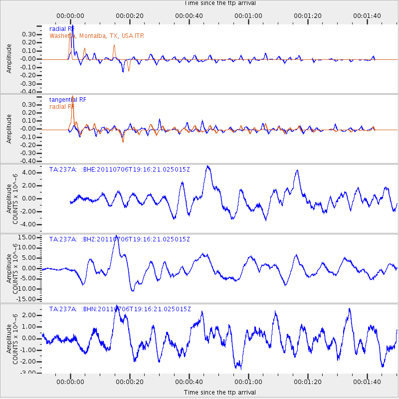
237A Washetta, Montalba, TX, USA - Earthquake Result Viewer
| Earthquake location: |
Kermadec Islands Region |
| Earthquake latitude/longitude: |
-29.5/-176.3 |
| Earthquake time(UTC): |
2011/07/06 (187) 19:03:18 GMT |
| Earthquake Depth: |
17 km |
| Earthquake Magnitude: |
7.0 MB, 7.8 MS, 7.6 MW, 7.6 MW |
| Earthquake Catalog/Contributor: |
WHDF/NEIC |
|
| Network: |
TA USArray Transportable Network (new EarthScope stations) |
| Station: |
237A Washetta, Montalba, TX, USA |
| Lat/Lon: |
32.00 N/95.81 W |
| Elevation: |
126 m |
|
| Distance: |
97.9 deg |
| Az: |
57.781 deg |
| Baz: |
240.196 deg |
| Ray Param: |
0.04007797 |
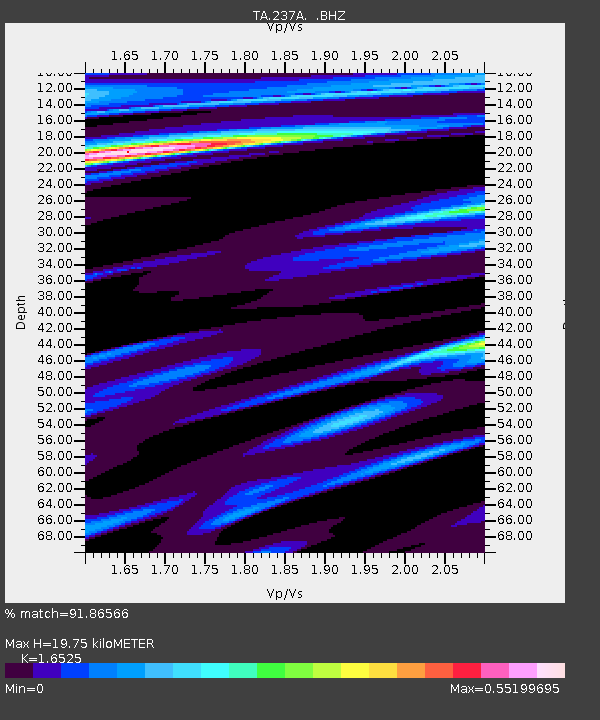
| Estimated Moho Depth: |
19.75 km |
| Estimated Crust Vp/Vs: |
1.65 |
| Assumed Crust Vp: |
6.245 km/s |
| Estimated Crust Vs: |
3.779 km/s |
| Estimated Crust Poisson's Ratio: |
0.21 |
|
| Radial Match: |
91.86566 % |
| Radial Bump: |
323 |
| Transverse Match: |
82.143394 % |
| Transverse Bump: |
400 |
| SOD ConfigId: |
395004 |
| Insert Time: |
2011-12-10 05:38:57.126 +0000 |
| GWidth: |
2.5 |
| Max Bumps: |
400 |
| Tol: |
0.001 |
|
Signal To Noise
| Channel | StoN | STA | LTA |
| TA:237A: :BHZ:20110706T19:16:21.025015Z | 17.244978 | 3.7318378E-6 | 2.164014E-7 |
| TA:237A: :BHN:20110706T19:16:21.025015Z | 2.397671 | 5.569253E-7 | 2.322776E-7 |
| TA:237A: :BHE:20110706T19:16:21.025015Z | 2.1229932 | 1.2018821E-6 | 5.6612623E-7 |
| Arrivals |
| Ps | 2.1 SECOND |
| PpPs | 8.2 SECOND |
| PsPs/PpSs | 10 SECOND |


