You are here: Home > Network List > TA - USArray Transportable Network (new EarthScope stations) Stations List
> Station 137A Heron Place, Grans Saline, TX, USA > Earthquake Result Viewer
137A Heron Place, Grans Saline, TX, USA - Earthquake Result Viewer
| Earthquake location: |
Kermadec Islands Region |
| Earthquake latitude/longitude: |
-29.5/-176.3 |
| Earthquake time(UTC): |
2011/07/06 (187) 19:03:18 GMT |
| Earthquake Depth: |
17 km |
| Earthquake Magnitude: |
7.0 MB, 7.8 MS, 7.6 MW, 7.6 MW |
| Earthquake Catalog/Contributor: |
WHDF/NEIC |
|
| Network: |
TA USArray Transportable Network (new EarthScope stations) |
| Station: |
137A Heron Place, Grans Saline, TX, USA |
| Lat/Lon: |
32.60 N/95.76 W |
| Elevation: |
141 m |
|
| Distance: |
98.2 deg |
| Az: |
57.282 deg |
| Baz: |
240.294 deg |
| Ray Param: |
0.039971765 |
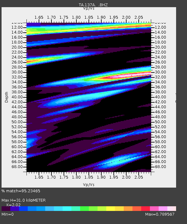
| Estimated Moho Depth: |
31.0 km |
| Estimated Crust Vp/Vs: |
2.02 |
| Assumed Crust Vp: |
6.245 km/s |
| Estimated Crust Vs: |
3.092 km/s |
| Estimated Crust Poisson's Ratio: |
0.34 |
|
| Radial Match: |
95.23465 % |
| Radial Bump: |
400 |
| Transverse Match: |
83.00289 % |
| Transverse Bump: |
400 |
| SOD ConfigId: |
395004 |
| Insert Time: |
2011-12-10 05:39:01.494 +0000 |
| GWidth: |
2.5 |
| Max Bumps: |
400 |
| Tol: |
0.001 |
|

Signal To Noise
| Channel | StoN | STA | LTA |
| TA:137A: :BHZ:20110706T19:16:22.49999Z | 20.061947 | 3.5537037E-6 | 1.7713653E-7 |
| TA:137A: :BHN:20110706T19:16:22.49999Z | 1.4185823 | 5.0015404E-7 | 3.5257312E-7 |
| TA:137A: :BHE:20110706T19:16:22.49999Z | 2.6243982 | 8.274945E-7 | 3.1530828E-7 |
| Arrivals |
| Ps | 5.1 SECOND |
| PpPs | 15 SECOND |
| PsPs/PpSs | 20 SECOND |


