You are here: Home > Network List > G - GEOSCOPE Stations List
> Station CAN Canberra, Australia > Earthquake Result Viewer
CAN Canberra, Australia - Earthquake Result Viewer
| Earthquake location: |
Southern Molucca Sea |
| Earthquake latitude/longitude: |
-0.1/124.7 |
| Earthquake time(UTC): |
2005/12/21 (355) 07:09:05 GMT |
| Earthquake Depth: |
25 km |
| Earthquake Magnitude: |
6.3 MB, 5.9 MS, 6.3 MW, 6.2 MW |
| Earthquake Catalog/Contributor: |
WHDF/NEIC |
|
| Network: |
G GEOSCOPE |
| Station: |
CAN Canberra, Australia |
| Lat/Lon: |
35.32 S/149.00 E |
| Elevation: |
650 m |
|
| Distance: |
41.8 deg |
| Az: |
149.624 deg |
| Baz: |
321.802 deg |
| Ray Param: |
0.07353733 |
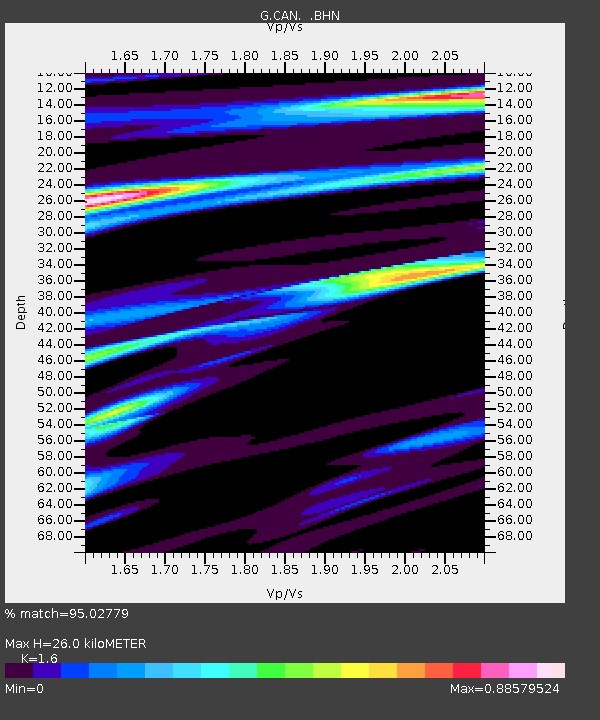
| Estimated Moho Depth: |
26.0 km |
| Estimated Crust Vp/Vs: |
1.60 |
| Assumed Crust Vp: |
6.633 km/s |
| Estimated Crust Vs: |
4.146 km/s |
| Estimated Crust Poisson's Ratio: |
0.18 |
|
| Radial Match: |
95.02779 % |
| Radial Bump: |
348 |
| Transverse Match: |
78.70413 % |
| Transverse Bump: |
400 |
| SOD ConfigId: |
2564 |
| Insert Time: |
2010-02-26 21:36:16.827 +0000 |
| GWidth: |
2.5 |
| Max Bumps: |
400 |
| Tol: |
0.001 |
|

Signal To Noise
| Channel | StoN | STA | LTA |
| G:CAN: :BHN:20051221T07:16:21.698015Z | 1.2693446 | 9.4058015E-7 | 7.409967E-7 |
| G:CAN: :BHE:20051221T07:16:21.698015Z | 1.2910566 | 6.1254343E-7 | 4.7445124E-7 |
| G:CAN: :BHZ:20051221T07:16:21.698015Z | 1.0091718 | 1.5591778E-6 | 1.5450072E-6 |
| Arrivals |
| Ps | 2.6 SECOND |
| PpPs | 9.4 SECOND |
| PsPs/PpSs | 12 SECOND |


