You are here: Home > Network List > TA - USArray Transportable Network (new EarthScope stations) Stations List
> Station E04D Cinebar, WA, USA > Earthquake Result Viewer
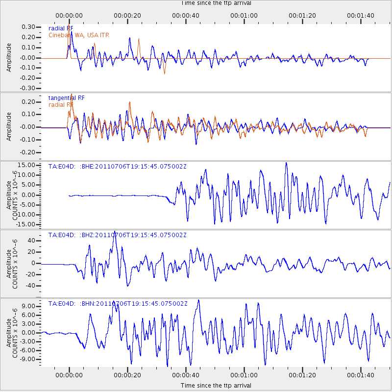
E04D Cinebar, WA, USA - Earthquake Result Viewer

| Earthquake location: |
Kermadec Islands Region |
| Earthquake latitude/longitude: |
-29.5/-176.3 |
| Earthquake time(UTC): |
2011/07/06 (187) 19:03:18 GMT |
| Earthquake Depth: |
17 km |
| Earthquake Magnitude: |
7.0 MB, 7.8 MS, 7.6 MW, 7.6 MW |
| Earthquake Catalog/Contributor: |
WHDF/NEIC |
|
| Network: |
TA USArray Transportable Network (new EarthScope stations) |
| Station: |
E04D Cinebar, WA, USA |
| Lat/Lon: |
46.56 N/122.57 W |
| Elevation: |
204 m |
|
| Distance: |
90.0 deg |
| Az: |
33.825 deg |
| Baz: |
224.666 deg |
| Ray Param: |
0.041705072 |
| Estimated Moho Depth: |
48.5 km |
| Estimated Crust Vp/Vs: |
1.87 |
| Assumed Crust Vp: |
6.566 km/s |
| Estimated Crust Vs: |
3.521 km/s |
| Estimated Crust Poisson's Ratio: |
0.30 |
|
| Radial Match: |
93.47806 % |
| Radial Bump: |
400 |
| Transverse Match: |
89.64932 % |
| Transverse Bump: |
400 |
| SOD ConfigId: |
395004 |
| Insert Time: |
2011-12-10 05:40:54.585 +0000 |
| GWidth: |
2.5 |
| Max Bumps: |
400 |
| Tol: |
0.001 |
|
Signal To Noise
| Channel | StoN | STA | LTA |
| TA:E04D: :BHZ:20110706T19:15:45.075002Z | 52.505905 | 8.527612E-6 | 1.6241245E-7 |
| TA:E04D: :BHN:20110706T19:15:45.075002Z | 7.111022 | 1.7229763E-6 | 2.4229658E-7 |
| TA:E04D: :BHE:20110706T19:15:45.075002Z | 10.496009 | 1.2318725E-6 | 1.1736581E-7 |
| Arrivals |
| Ps | 6.5 SECOND |
| PpPs | 21 SECOND |
| PsPs/PpSs | 27 SECOND |


