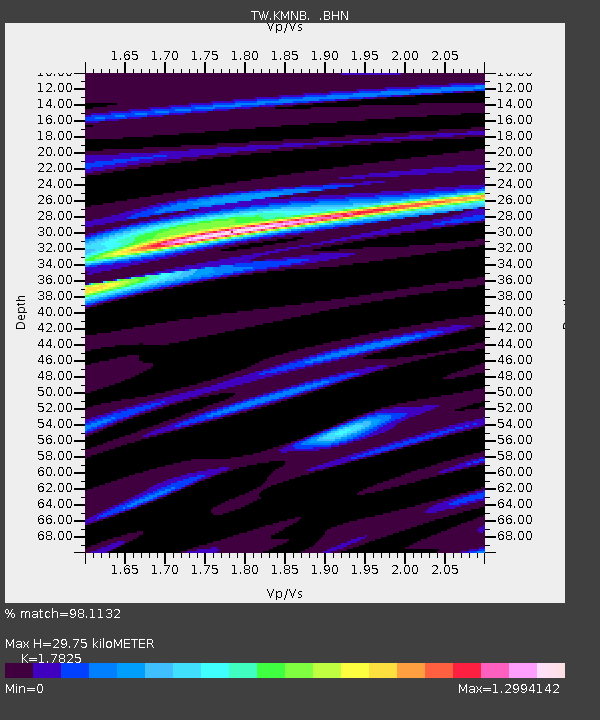
KMNB KING-MEN - Earthquake Result Viewer

Earthquake location: Kermadec Islands Region
Earthquake latitude/longitude: -29.5/-176.3
Earthquake time(UTC): 2011/07/06 (187) 19:03:18 GMT
Earthquake Depth: 17 km
Earthquake Magnitude: 7.0 MB, 7.8 MS, 7.6 MW, 7.6 MW
Earthquake Catalog/Contributor: WHDF/NEIC
Network: TW Broadband Array in Taiwan for Seismology
Station: KMNB KING-MEN
Lat/Lon: 24.46 N/118.39 E
Elevation: 43 m
Distance: 82.5 deg
Az: 303.404 deg
Baz: 127.03 deg
Ray Param: 0.046818294
Estimated Moho Depth: 29.75 km
Estimated Crust Vp/Vs: 1.78
Assumed Crust Vp: 6.472 km/s
Estimated Crust Vs: 3.631 km/s
Estimated Crust Poisson's Ratio: 0.27
Radial Match: 98.1132 %
Radial Bump: 297
Transverse Match: 90.63138 %
Transverse Bump: 400
SOD ConfigId: 395004
Insert Time: 2011-12-10 05:41:33.619 +0000
GWidth: 2.5
Max Bumps: 400
Tol: 0.001

Signal To Noise

ChannelStoNSTALTA
TW:KMNB: :BHZ:20110706T19:15:08.52001Z37.2981077.3230617E-61.9633869E-7
TW:KMNB: :BHN:20110706T19:15:08.52001Z11.1643463.08944E-62.767238E-7
TW:KMNB: :BHE:20110706T19:15:08.52001Z13.9340234.4966137E-63.2270748E-7
Arrivals
Ps3.7 SECOND
PpPs12 SECOND
PsPs/PpSs16 SECOND