You are here: Home > Network List > UW - Pacific Northwest Regional Seismic Network Stations List
> Station TAKO Tahkenitch, OR CREST BB SMO > Earthquake Result Viewer
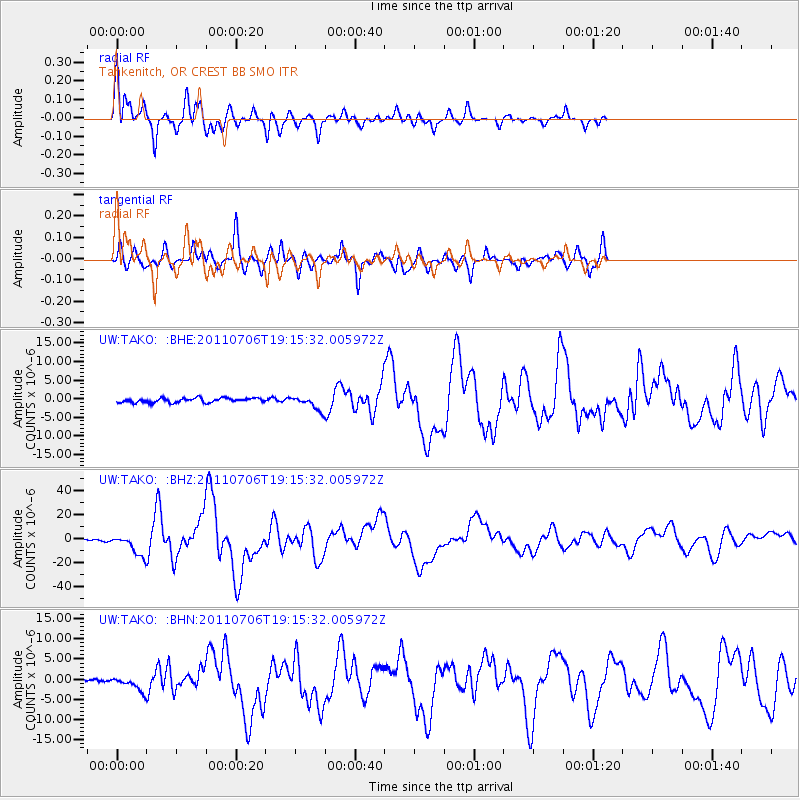
TAKO Tahkenitch, OR CREST BB SMO - Earthquake Result Viewer

| Earthquake location: |
Kermadec Islands Region |
| Earthquake latitude/longitude: |
-29.5/-176.3 |
| Earthquake time(UTC): |
2011/07/06 (187) 19:03:18 GMT |
| Earthquake Depth: |
17 km |
| Earthquake Magnitude: |
7.0 MB, 7.8 MS, 7.6 MW, 7.6 MW |
| Earthquake Catalog/Contributor: |
WHDF/NEIC |
|
| Network: |
UW Pacific Northwest Regional Seismic Network |
| Station: |
TAKO Tahkenitch, OR CREST BB SMO |
| Lat/Lon: |
43.74 N/124.08 W |
| Elevation: |
46 m |
|
| Distance: |
87.2 deg |
| Az: |
35.015 deg |
| Baz: |
223.624 deg |
| Ray Param: |
0.043473642 |
| Estimated Moho Depth: |
10.0 km |
| Estimated Crust Vp/Vs: |
1.99 |
| Assumed Crust Vp: |
6.048 km/s |
| Estimated Crust Vs: |
3.039 km/s |
| Estimated Crust Poisson's Ratio: |
0.33 |
|
| Radial Match: |
86.77649 % |
| Radial Bump: |
400 |
| Transverse Match: |
70.411354 % |
| Transverse Bump: |
349 |
| SOD ConfigId: |
395004 |
| Insert Time: |
2011-12-10 05:42:38.376 +0000 |
| GWidth: |
2.5 |
| Max Bumps: |
400 |
| Tol: |
0.001 |
|
Signal To Noise
| Channel | StoN | STA | LTA |
| UW:TAKO: :BHZ:20110706T19:15:32.005972Z | 16.775366 | 8.473407E-6 | 5.051101E-7 |
| UW:TAKO: :BHN:20110706T19:15:32.005972Z | 2.7991788 | 1.581568E-6 | 5.650114E-7 |
| UW:TAKO: :BHE:20110706T19:15:32.005972Z | 3.0115573 | 1.81795E-6 | 6.036578E-7 |
| Arrivals |
| Ps | 1.7 SECOND |
| PpPs | 4.9 SECOND |
| PsPs/PpSs | 6.5 SECOND |


