You are here: Home > Network List > AU - Australian Seismological Centre Stations List
> Station QIS Mount Isa, Queensland > Earthquake Result Viewer
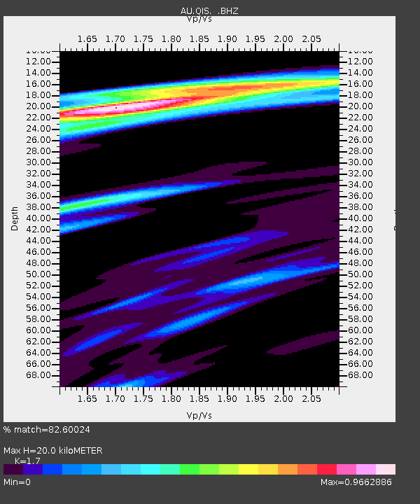
QIS Mount Isa, Queensland - Earthquake Result Viewer
| Earthquake location: |
Kermadec Islands Region |
| Earthquake latitude/longitude: |
-29.0/-176.7 |
| Earthquake time(UTC): |
2011/07/07 (188) 09:10:50 GMT |
| Earthquake Depth: |
10 km |
| Earthquake Magnitude: |
5.6 MB, 5.6 MS, 5.7 MW |
| Earthquake Catalog/Contributor: |
WHDF/NEIC |
|
| Network: |
AU Australian Seismological Centre |
| Station: |
QIS Mount Isa, Queensland |
| Lat/Lon: |
20.56 S/139.61 E |
| Elevation: |
450 m |
|
| Distance: |
40.4 deg |
| Az: |
271.837 deg |
| Baz: |
110.849 deg |
| Ray Param: |
0.07444567 |
| Estimated Moho Depth: |
20.0 km |
| Estimated Crust Vp/Vs: |
1.70 |
| Assumed Crust Vp: |
6.577 km/s |
| Estimated Crust Vs: |
3.869 km/s |
| Estimated Crust Poisson's Ratio: |
0.24 |
|
| Radial Match: |
82.60024 % |
| Radial Bump: |
300 |
| Transverse Match: |
72.81424 % |
| Transverse Bump: |
305 |
| SOD ConfigId: |
395004 |
| Insert Time: |
2011-12-10 05:50:03.122 +0000 |
| GWidth: |
2.5 |
| Max Bumps: |
400 |
| Tol: |
0.001 |
|

Signal To Noise
| Channel | StoN | STA | LTA |
| AU:QIS: :BHZ:20110707T09:17:57.169993Z | 5.665482 | 6.709329E-7 | 1.1842467E-7 |
| AU:QIS: :BHN:20110707T09:17:57.169993Z | 1.2479876 | 1.5606486E-7 | 1.250532E-7 |
| AU:QIS: :BHE:20110707T09:17:57.169993Z | 1.9433807 | 3.9252006E-7 | 2.0197797E-7 |
| Arrivals |
| Ps | 2.3 SECOND |
| PpPs | 7.6 SECOND |
| PsPs/PpSs | 9.9 SECOND |


