You are here: Home > Network List > AV - Alaska Volcano Observatory Stations List
> Station SPCR Ckakachatna River, Mount Spurr, Alaska > Earthquake Result Viewer
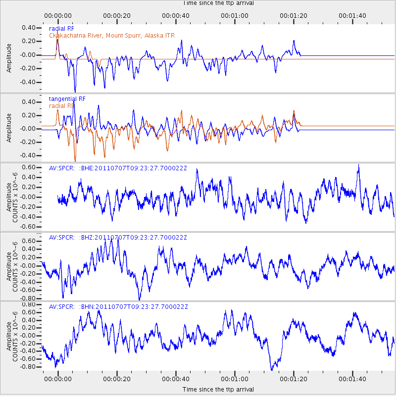
SPCR Ckakachatna River, Mount Spurr, Alaska - Earthquake Result Viewer
*The percent match for this event was below the threshold and hence no stack was calculated.
| Earthquake location: |
Kermadec Islands Region |
| Earthquake latitude/longitude: |
-29.0/-176.7 |
| Earthquake time(UTC): |
2011/07/07 (188) 09:10:50 GMT |
| Earthquake Depth: |
10 km |
| Earthquake Magnitude: |
5.6 MB, 5.6 MS, 5.7 MW |
| Earthquake Catalog/Contributor: |
WHDF/NEIC |
|
| Network: |
AV Alaska Volcano Observatory |
| Station: |
SPCR Ckakachatna River, Mount Spurr, Alaska |
| Lat/Lon: |
61.20 N/152.21 W |
| Elevation: |
984 m |
|
| Distance: |
92.0 deg |
| Az: |
11.593 deg |
| Baz: |
201.324 deg |
| Ray Param: |
$rayparam |
*The percent match for this event was below the threshold and hence was not used in the summary stack. |
|
| Radial Match: |
71.230705 % |
| Radial Bump: |
400 |
| Transverse Match: |
62.46779 % |
| Transverse Bump: |
400 |
| SOD ConfigId: |
395004 |
| Insert Time: |
2011-12-10 05:51:23.003 +0000 |
| GWidth: |
2.5 |
| Max Bumps: |
400 |
| Tol: |
0.001 |
|
Signal To Noise
| Channel | StoN | STA | LTA |
| AV:SPCR: :BHZ:20110707T09:23:27.700022Z | 2.027961 | 4.122132E-7 | 2.0326485E-7 |
| AV:SPCR: :BHN:20110707T09:23:27.700022Z | 3.48344 | 6.48326E-7 | 1.8611662E-7 |
| AV:SPCR: :BHE:20110707T09:23:27.700022Z | 0.6222195 | 9.456068E-8 | 1.519732E-7 |
| Arrivals |
| Ps | |
| PpPs | |
| PsPs/PpSs | |


