You are here: Home > Network List > TA - USArray Transportable Network (new EarthScope stations) Stations List
> Station 121A Cookes Peak, Deming, NM, USA > Earthquake Result Viewer
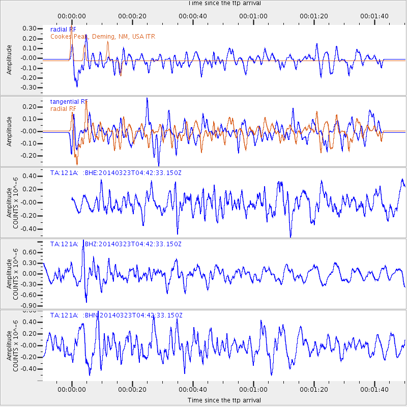
121A Cookes Peak, Deming, NM, USA - Earthquake Result Viewer
*The percent match for this event was below the threshold and hence no stack was calculated.
| Earthquake location: |
Fiji Islands Region |
| Earthquake latitude/longitude: |
-20.7/-178.8 |
| Earthquake time(UTC): |
2014/03/23 (082) 04:31:30 GMT |
| Earthquake Depth: |
645 km |
| Earthquake Magnitude: |
5.4 mb |
| Earthquake Catalog/Contributor: |
ISC/ISC |
|
| Network: |
TA USArray Transportable Network (new EarthScope stations) |
| Station: |
121A Cookes Peak, Deming, NM, USA |
| Lat/Lon: |
32.53 N/107.79 W |
| Elevation: |
1652 m |
|
| Distance: |
86.0 deg |
| Az: |
53.199 deg |
| Baz: |
242.558 deg |
| Ray Param: |
$rayparam |
*The percent match for this event was below the threshold and hence was not used in the summary stack. |
|
| Radial Match: |
66.208084 % |
| Radial Bump: |
400 |
| Transverse Match: |
58.911728 % |
| Transverse Bump: |
400 |
| SOD ConfigId: |
3390531 |
| Insert Time: |
2019-04-10 20:39:31.000 +0000 |
| GWidth: |
2.5 |
| Max Bumps: |
400 |
| Tol: |
0.001 |
|
Signal To Noise
| Channel | StoN | STA | LTA |
| TA:121A: :BHZ:20140323T04:42:33.150Z | 1.8156769 | 3.7442223E-7 | 2.0621633E-7 |
| TA:121A: :BHN:20140323T04:42:33.150Z | 2.1109564 | 2.323902E-7 | 1.1008764E-7 |
| TA:121A: :BHE:20140323T04:42:33.150Z | 1.3432778 | 1.47959E-7 | 1.1014773E-7 |
| Arrivals |
| Ps | |
| PpPs | |
| PsPs/PpSs | |


