You are here: Home > Network List > JP - Japan Meteorological Agency Seismic Network Stations List
> Station ASAJ Kamikawa Asahi > Earthquake Result Viewer
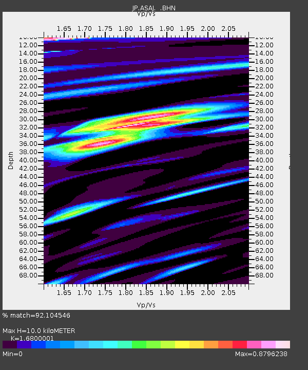
ASAJ Kamikawa Asahi - Earthquake Result Viewer
| Earthquake location: |
Kermadec Islands Region |
| Earthquake latitude/longitude: |
-29.0/-176.7 |
| Earthquake time(UTC): |
2011/07/07 (188) 09:10:50 GMT |
| Earthquake Depth: |
10 km |
| Earthquake Magnitude: |
5.6 MB, 5.6 MS, 5.7 MW |
| Earthquake Catalog/Contributor: |
WHDF/NEIC |
|
| Network: |
JP Japan Meteorological Agency Seismic Network |
| Station: |
ASAJ Kamikawa Asahi |
| Lat/Lon: |
44.12 N/142.59 E |
| Elevation: |
220 m |
|
| Distance: |
81.7 deg |
| Az: |
331.668 deg |
| Baz: |
144.737 deg |
| Ray Param: |
0.04739125 |
| Estimated Moho Depth: |
10.0 km |
| Estimated Crust Vp/Vs: |
1.68 |
| Assumed Crust Vp: |
6.183 km/s |
| Estimated Crust Vs: |
3.68 km/s |
| Estimated Crust Poisson's Ratio: |
0.23 |
|
| Radial Match: |
92.104546 % |
| Radial Bump: |
400 |
| Transverse Match: |
78.37137 % |
| Transverse Bump: |
400 |
| SOD ConfigId: |
395004 |
| Insert Time: |
2011-12-10 05:55:13.025 +0000 |
| GWidth: |
2.5 |
| Max Bumps: |
400 |
| Tol: |
0.001 |
|

Signal To Noise
| Channel | StoN | STA | LTA |
| JP:ASAJ: :BHZ:20110707T09:22:37.399973Z | 6.8853335 | 5.7898353E-7 | 8.408939E-8 |
| JP:ASAJ: :BHN:20110707T09:22:37.399973Z | 2.9750419 | 1.4046813E-7 | 4.7215515E-8 |
| JP:ASAJ: :BHE:20110707T09:22:37.399973Z | 1.7280453 | 2.3256644E-7 | 1.3458353E-7 |
| Arrivals |
| Ps | 1.1 SECOND |
| PpPs | 4.2 SECOND |
| PsPs/PpSs | 5.4 SECOND |


