You are here: Home > Network List > TA - USArray Transportable Network (new EarthScope stations) Stations List
> Station O03D Paynes Creek, CA, USA > Earthquake Result Viewer
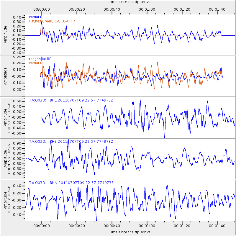
O03D Paynes Creek, CA, USA - Earthquake Result Viewer
*The percent match for this event was below the threshold and hence no stack was calculated.
| Earthquake location: |
Kermadec Islands Region |
| Earthquake latitude/longitude: |
-29.0/-176.7 |
| Earthquake time(UTC): |
2011/07/07 (188) 09:10:50 GMT |
| Earthquake Depth: |
10 km |
| Earthquake Magnitude: |
5.6 MB, 5.6 MS, 5.7 MW |
| Earthquake Catalog/Contributor: |
WHDF/NEIC |
|
| Network: |
TA USArray Transportable Network (new EarthScope stations) |
| Station: |
O03D Paynes Creek, CA, USA |
| Lat/Lon: |
40.29 N/121.80 W |
| Elevation: |
968 m |
|
| Distance: |
85.7 deg |
| Az: |
38.873 deg |
| Baz: |
225.967 deg |
| Ray Param: |
$rayparam |
*The percent match for this event was below the threshold and hence was not used in the summary stack. |
|
| Radial Match: |
62.821136 % |
| Radial Bump: |
400 |
| Transverse Match: |
59.74844 % |
| Transverse Bump: |
400 |
| SOD ConfigId: |
395004 |
| Insert Time: |
2011-12-10 05:58:23.969 +0000 |
| GWidth: |
2.5 |
| Max Bumps: |
400 |
| Tol: |
0.001 |
|
Signal To Noise
| Channel | StoN | STA | LTA |
| TA:O03D: :BHZ:20110707T09:22:57.774973Z | 2.1116712 | 2.9469135E-7 | 1.3955362E-7 |
| TA:O03D: :BHN:20110707T09:22:57.774973Z | 0.6191056 | 1.16759324E-7 | 1.8859356E-7 |
| TA:O03D: :BHE:20110707T09:22:57.774973Z | 1.2045736 | 2.3948917E-7 | 1.9881655E-7 |
| Arrivals |
| Ps | |
| PpPs | |
| PsPs/PpSs | |


