You are here: Home > Network List > US - United States National Seismic Network Stations List
> Station MNTX Cornudas Mountains, Texas, USA > Earthquake Result Viewer
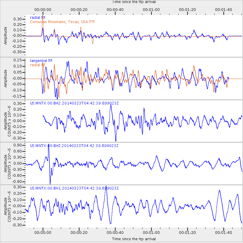
MNTX Cornudas Mountains, Texas, USA - Earthquake Result Viewer
*The percent match for this event was below the threshold and hence no stack was calculated.
| Earthquake location: |
Fiji Islands Region |
| Earthquake latitude/longitude: |
-20.7/-178.8 |
| Earthquake time(UTC): |
2014/03/23 (082) 04:31:30 GMT |
| Earthquake Depth: |
645 km |
| Earthquake Magnitude: |
5.4 mb |
| Earthquake Catalog/Contributor: |
ISC/ISC |
|
| Network: |
US United States National Seismic Network |
| Station: |
MNTX Cornudas Mountains, Texas, USA |
| Lat/Lon: |
31.70 N/105.38 W |
| Elevation: |
404 m |
|
| Distance: |
87.5 deg |
| Az: |
54.862 deg |
| Baz: |
243.924 deg |
| Ray Param: |
$rayparam |
*The percent match for this event was below the threshold and hence was not used in the summary stack. |
|
| Radial Match: |
66.12272 % |
| Radial Bump: |
400 |
| Transverse Match: |
51.117233 % |
| Transverse Bump: |
366 |
| SOD ConfigId: |
3390531 |
| Insert Time: |
2019-04-10 20:40:06.903 +0000 |
| GWidth: |
2.5 |
| Max Bumps: |
400 |
| Tol: |
0.001 |
|
Signal To Noise
| Channel | StoN | STA | LTA |
| US:MNTX:00:BHZ:20140323T04:42:39.899023Z | 3.0621364 | 4.3133412E-7 | 1.4086052E-7 |
| US:MNTX:00:BH1:20140323T04:42:39.899023Z | 1.4634339 | 7.693234E-8 | 5.256974E-8 |
| US:MNTX:00:BH2:20140323T04:42:39.899023Z | 1.6028669 | 1.181831E-7 | 7.373232E-8 |
| Arrivals |
| Ps | |
| PpPs | |
| PsPs/PpSs | |


