You are here: Home > Network List > AK - Alaska Regional Network Stations List
> Station MDM Murphy Dome > Earthquake Result Viewer
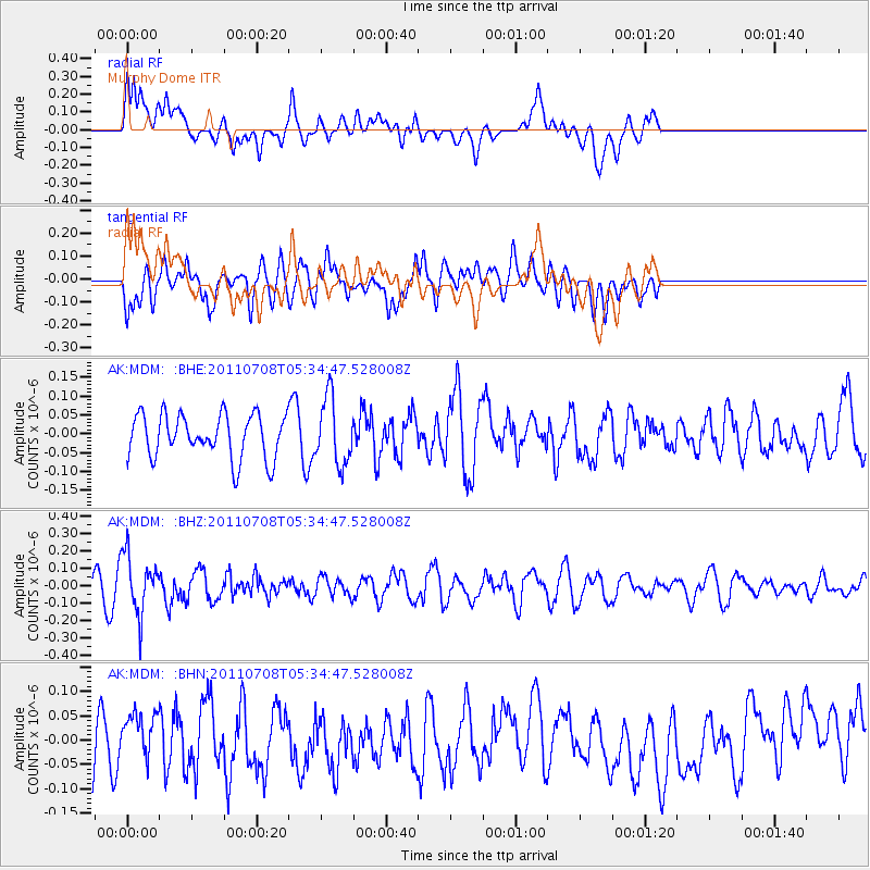
MDM Murphy Dome - Earthquake Result Viewer
*The percent match for this event was below the threshold and hence no stack was calculated.
| Earthquake location: |
Minahassa Peninsula, Sulawesi |
| Earthquake latitude/longitude: |
0.1/123.2 |
| Earthquake time(UTC): |
2011/07/08 (189) 05:22:40 GMT |
| Earthquake Depth: |
159 km |
| Earthquake Magnitude: |
5.6 MB, 5.4 MW, 5.3 MW |
| Earthquake Catalog/Contributor: |
WHDF/NEIC |
|
| Network: |
AK Alaska Regional Network |
| Station: |
MDM Murphy Dome |
| Lat/Lon: |
64.96 N/148.23 W |
| Elevation: |
634 m |
|
| Distance: |
89.3 deg |
| Az: |
25.182 deg |
| Baz: |
268.722 deg |
| Ray Param: |
$rayparam |
*The percent match for this event was below the threshold and hence was not used in the summary stack. |
|
| Radial Match: |
48.089207 % |
| Radial Bump: |
400 |
| Transverse Match: |
48.408726 % |
| Transverse Bump: |
400 |
| SOD ConfigId: |
395004 |
| Insert Time: |
2011-12-10 06:18:37.701 +0000 |
| GWidth: |
2.5 |
| Max Bumps: |
400 |
| Tol: |
0.001 |
|
Signal To Noise
| Channel | StoN | STA | LTA |
| AK:MDM: :BHZ:20110708T05:34:47.528008Z | 2.2445982 | 1.7038234E-7 | 7.590772E-8 |
| AK:MDM: :BHN:20110708T05:34:47.528008Z | 0.97170883 | 4.6090893E-8 | 4.7432824E-8 |
| AK:MDM: :BHE:20110708T05:34:47.528008Z | 1.5312082 | 8.8720896E-8 | 5.7941758E-8 |
| Arrivals |
| Ps | |
| PpPs | |
| PsPs/PpSs | |


