You are here: Home > Network List > IC - New China Digital Seismograph Network Stations List
> Station LSA Tibet, China > Earthquake Result Viewer
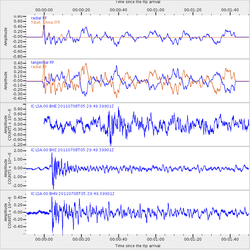
LSA Tibet, China - Earthquake Result Viewer
*The percent match for this event was below the threshold and hence no stack was calculated.
| Earthquake location: |
Minahassa Peninsula, Sulawesi |
| Earthquake latitude/longitude: |
0.1/123.2 |
| Earthquake time(UTC): |
2011/07/08 (189) 05:22:40 GMT |
| Earthquake Depth: |
159 km |
| Earthquake Magnitude: |
5.6 MB, 5.4 MW, 5.3 MW |
| Earthquake Catalog/Contributor: |
WHDF/NEIC |
|
| Network: |
IC New China Digital Seismograph Network |
| Station: |
LSA Tibet, China |
| Lat/Lon: |
29.70 N/91.13 E |
| Elevation: |
3660 m |
|
| Distance: |
42.4 deg |
| Az: |
316.728 deg |
| Baz: |
128.014 deg |
| Ray Param: |
$rayparam |
*The percent match for this event was below the threshold and hence was not used in the summary stack. |
|
| Radial Match: |
59.87787 % |
| Radial Bump: |
400 |
| Transverse Match: |
53.61 % |
| Transverse Bump: |
400 |
| SOD ConfigId: |
395004 |
| Insert Time: |
2011-12-10 06:19:55.780 +0000 |
| GWidth: |
2.5 |
| Max Bumps: |
400 |
| Tol: |
0.001 |
|
Signal To Noise
| Channel | StoN | STA | LTA |
| IC:LSA:00:BHZ:20110708T05:29:49.39901Z | 8.348196 | 5.2198163E-7 | 6.2526276E-8 |
| IC:LSA:00:BHN:20110708T05:29:49.39901Z | 4.451846 | 1.3716317E-7 | 3.08104E-8 |
| IC:LSA:00:BHE:20110708T05:29:49.39901Z | 1.4328802 | 3.3334314E-7 | 2.3263854E-7 |
| Arrivals |
| Ps | |
| PpPs | |
| PsPs/PpSs | |


