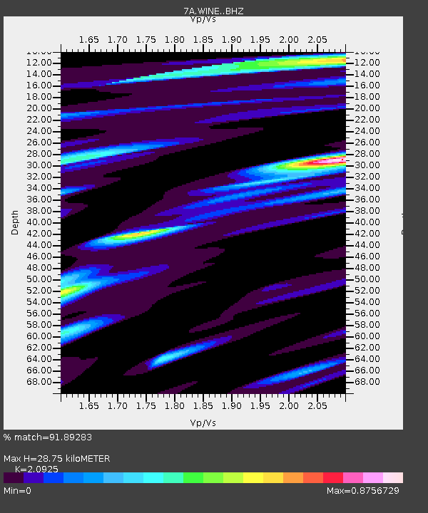
WINE Liberty, Virginia USA - Earthquake Result Viewer

Earthquake location: Near Coast Of Northern Chile
Earthquake latitude/longitude: -19.7/-70.8
Earthquake time(UTC): 2014/03/23 (082) 18:20:03 GMT
Earthquake Depth: 35 km
Earthquake Magnitude: 6.0 MB, 6.2 MWB, 6.2 MWW, 6.3 MWC
Earthquake Catalog/Contributor: NEIC PDE/NEIC COMCAT
Network: 7A Mid-Atlantic Geophysical Integrative Collaboration
Station: WINE Liberty, Virginia USA
Lat/Lon: 38.16 N/78.32 W
Elevation: 119 m
Distance: 58.0 deg
Az: 353.025 deg
Baz: 171.656 deg
Ray Param: 0.063051604
Estimated Moho Depth: 28.75 km
Estimated Crust Vp/Vs: 2.09
Assumed Crust Vp: 6.159 km/s
Estimated Crust Vs: 2.943 km/s
Estimated Crust Poisson's Ratio: 0.35
Radial Match: 91.89283 %
Radial Bump: 400
Transverse Match: 67.65179 %
Transverse Bump: 400
SOD ConfigId: 3390531
Insert Time: 2019-04-10 20:41:28.930 +0000
GWidth: 2.5
Max Bumps: 400
Tol: 0.001

Signal To Noise

ChannelStoNSTALTA
7A:WINE: :BHZ:20140323T18:29:22.174971Z6.4371181.0706786E-61.6632887E-7
7A:WINE: :BHN:20140323T18:29:22.174971Z4.4463325.2941976E-71.1906888E-7
7A:WINE: :BHE:20140323T18:29:22.174971Z1.46899191.8677268E-71.2714344E-7
Arrivals
Ps5.3 SECOND
PpPs14 SECOND
PsPs/PpSs19 SECOND