You are here: Home > Network List > KN - Kyrgyz Seismic Telemetry Network Stations List
> Station TKM2 KN.TKM2 > Earthquake Result Viewer
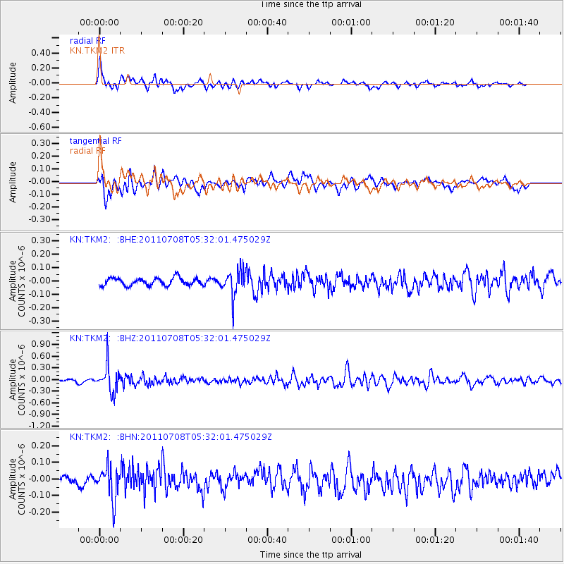
TKM2 KN.TKM2 - Earthquake Result Viewer
*The percent match for this event was below the threshold and hence no stack was calculated.
| Earthquake location: |
Minahassa Peninsula, Sulawesi |
| Earthquake latitude/longitude: |
0.1/123.2 |
| Earthquake time(UTC): |
2011/07/08 (189) 05:22:40 GMT |
| Earthquake Depth: |
159 km |
| Earthquake Magnitude: |
5.6 MB, 5.4 MW, 5.3 MW |
| Earthquake Catalog/Contributor: |
WHDF/NEIC |
|
| Network: |
KN Kyrgyz Seismic Telemetry Network |
| Station: |
TKM2 KN.TKM2 |
| Lat/Lon: |
42.92 N/75.60 E |
| Elevation: |
2020 m |
|
| Distance: |
60.2 deg |
| Az: |
321.292 deg |
| Baz: |
121.645 deg |
| Ray Param: |
$rayparam |
*The percent match for this event was below the threshold and hence was not used in the summary stack. |
|
| Radial Match: |
67.52443 % |
| Radial Bump: |
400 |
| Transverse Match: |
59.496395 % |
| Transverse Bump: |
400 |
| SOD ConfigId: |
395004 |
| Insert Time: |
2011-12-10 06:21:28.146 +0000 |
| GWidth: |
2.5 |
| Max Bumps: |
400 |
| Tol: |
0.001 |
|
Signal To Noise
| Channel | StoN | STA | LTA |
| KN:TKM2: :BHZ:20110708T05:32:01.475029Z | 10.8027 | 3.4110118E-7 | 3.157555E-8 |
| KN:TKM2: :BHN:20110708T05:32:01.475029Z | 3.0027719 | 9.820274E-8 | 3.270403E-8 |
| KN:TKM2: :BHE:20110708T05:32:01.475029Z | 3.5090322 | 9.9543485E-8 | 2.8367788E-8 |
| Arrivals |
| Ps | |
| PpPs | |
| PsPs/PpSs | |


