You are here: Home > Network List > TA - USArray Transportable Network (new EarthScope stations) Stations List
> Station K32A Verdigre, NE, USA > Earthquake Result Viewer
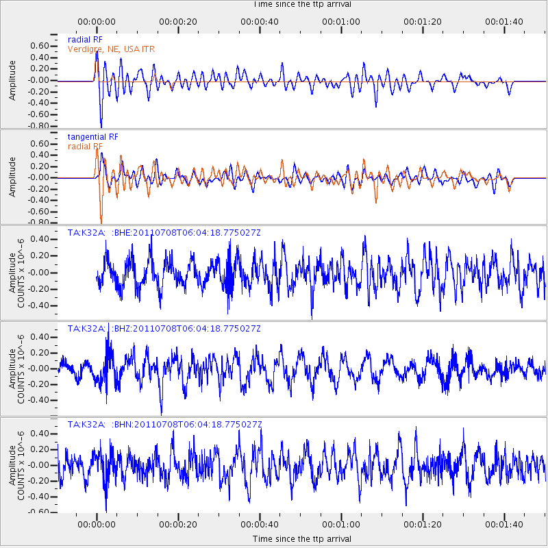
K32A Verdigre, NE, USA - Earthquake Result Viewer
*The percent match for this event was below the threshold and hence no stack was calculated.
| Earthquake location: |
Central Mid-Atlantic Ridge |
| Earthquake latitude/longitude: |
1.0/-26.4 |
| Earthquake time(UTC): |
2011/07/08 (189) 05:53:03 GMT |
| Earthquake Depth: |
10 km |
| Earthquake Magnitude: |
5.6 MW, 5.2 MS, 5.4 MB |
| Earthquake Catalog/Contributor: |
WHDF/NEIC |
|
| Network: |
TA USArray Transportable Network (new EarthScope stations) |
| Station: |
K32A Verdigre, NE, USA |
| Lat/Lon: |
42.66 N/97.97 W |
| Elevation: |
512 m |
|
| Distance: |
75.8 deg |
| Az: |
313.807 deg |
| Baz: |
101.984 deg |
| Ray Param: |
$rayparam |
*The percent match for this event was below the threshold and hence was not used in the summary stack. |
|
| Radial Match: |
71.11759 % |
| Radial Bump: |
400 |
| Transverse Match: |
60.382397 % |
| Transverse Bump: |
400 |
| SOD ConfigId: |
395004 |
| Insert Time: |
2011-12-10 06:38:05.433 +0000 |
| GWidth: |
2.5 |
| Max Bumps: |
400 |
| Tol: |
0.001 |
|
Signal To Noise
| Channel | StoN | STA | LTA |
| TA:K32A: :BHZ:20110708T06:04:18.775027Z | 2.02863 | 1.8792696E-7 | 9.263738E-8 |
| TA:K32A: :BHN:20110708T06:04:18.775027Z | 1.4466262 | 1.7872405E-7 | 1.2354543E-7 |
| TA:K32A: :BHE:20110708T06:04:18.775027Z | 1.1334795 | 1.7732022E-7 | 1.5643884E-7 |
| Arrivals |
| Ps | |
| PpPs | |
| PsPs/PpSs | |


