You are here: Home > Network List > TA - USArray Transportable Network (new EarthScope stations) Stations List
> Station 121A Cookes Peak, Deming, NM, USA > Earthquake Result Viewer
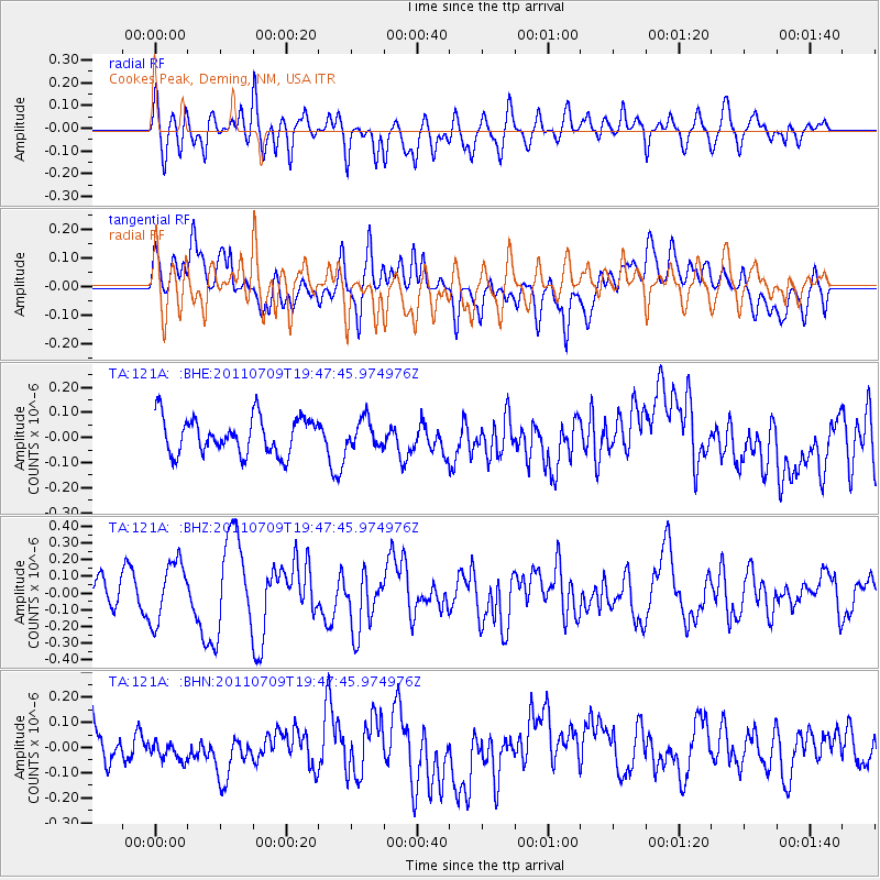
121A Cookes Peak, Deming, NM, USA - Earthquake Result Viewer
*The percent match for this event was below the threshold and hence no stack was calculated.
| Earthquake location: |
Kermadec Islands, New Zealand |
| Earthquake latitude/longitude: |
-29.4/-177.0 |
| Earthquake time(UTC): |
2011/07/09 (190) 19:35:18 GMT |
| Earthquake Depth: |
15 km |
| Earthquake Magnitude: |
5.5 MB, 5.8 MS, 5.9 MW, 5.7 MW |
| Earthquake Catalog/Contributor: |
WHDF/NEIC |
|
| Network: |
TA USArray Transportable Network (new EarthScope stations) |
| Station: |
121A Cookes Peak, Deming, NM, USA |
| Lat/Lon: |
32.53 N/107.79 W |
| Elevation: |
1652 m |
|
| Distance: |
90.0 deg |
| Az: |
52.165 deg |
| Baz: |
234.645 deg |
| Ray Param: |
$rayparam |
*The percent match for this event was below the threshold and hence was not used in the summary stack. |
|
| Radial Match: |
58.90009 % |
| Radial Bump: |
400 |
| Transverse Match: |
51.003765 % |
| Transverse Bump: |
400 |
| SOD ConfigId: |
395004 |
| Insert Time: |
2011-12-16 05:29:15.641 +0000 |
| GWidth: |
2.5 |
| Max Bumps: |
400 |
| Tol: |
0.001 |
|
Signal To Noise
| Channel | StoN | STA | LTA |
| TA:121A: :BHZ:20110709T19:47:45.974976Z | 2.621411 | 1.7977192E-7 | 6.85783E-8 |
| TA:121A: :BHN:20110709T19:47:45.974976Z | 0.45723078 | 3.598471E-8 | 7.870141E-8 |
| TA:121A: :BHE:20110709T19:47:45.974976Z | 0.74932736 | 5.4507353E-8 | 7.274171E-8 |
| Arrivals |
| Ps | |
| PpPs | |
| PsPs/PpSs | |


