You are here: Home > Network List > TA - USArray Transportable Network (new EarthScope stations) Stations List
> Station X33A Lawton, OK, USA > Earthquake Result Viewer
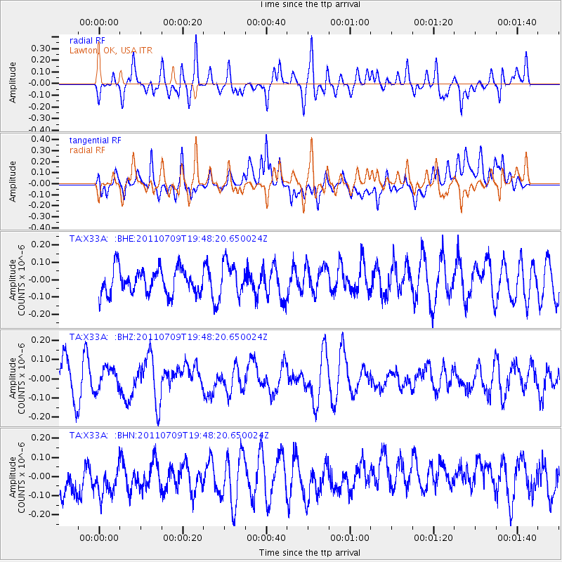
X33A Lawton, OK, USA - Earthquake Result Viewer
*The percent match for this event was below the threshold and hence no stack was calculated.
| Earthquake location: |
Kermadec Islands, New Zealand |
| Earthquake latitude/longitude: |
-29.4/-177.0 |
| Earthquake time(UTC): |
2011/07/09 (190) 19:35:18 GMT |
| Earthquake Depth: |
15 km |
| Earthquake Magnitude: |
5.5 MB, 5.8 MS, 5.9 MW, 5.7 MW |
| Earthquake Catalog/Contributor: |
WHDF/NEIC |
|
| Network: |
TA USArray Transportable Network (new EarthScope stations) |
| Station: |
X33A Lawton, OK, USA |
| Lat/Lon: |
34.54 N/98.50 W |
| Elevation: |
346 m |
|
| Distance: |
97.6 deg |
| Az: |
54.7 deg |
| Baz: |
239.59 deg |
| Ray Param: |
$rayparam |
*The percent match for this event was below the threshold and hence was not used in the summary stack. |
|
| Radial Match: |
52.75362 % |
| Radial Bump: |
332 |
| Transverse Match: |
32.179955 % |
| Transverse Bump: |
400 |
| SOD ConfigId: |
395004 |
| Insert Time: |
2011-12-16 05:29:36.241 +0000 |
| GWidth: |
2.5 |
| Max Bumps: |
400 |
| Tol: |
0.001 |
|
Signal To Noise
| Channel | StoN | STA | LTA |
| TA:X33A: :BHZ:20110709T19:48:20.650024Z | 0.6738136 | 5.4875777E-8 | 8.144059E-8 |
| TA:X33A: :BHN:20110709T19:48:20.650024Z | 0.80528116 | 1.3164988E-7 | 1.6348312E-7 |
| TA:X33A: :BHE:20110709T19:48:20.650024Z | 1.2868013 | 9.331419E-8 | 7.251639E-8 |
| Arrivals |
| Ps | |
| PpPs | |
| PsPs/PpSs | |


