You are here: Home > Network List > TA - USArray Transportable Network (new EarthScope stations) Stations List
> Station 136A Ennis, TX, USA > Earthquake Result Viewer
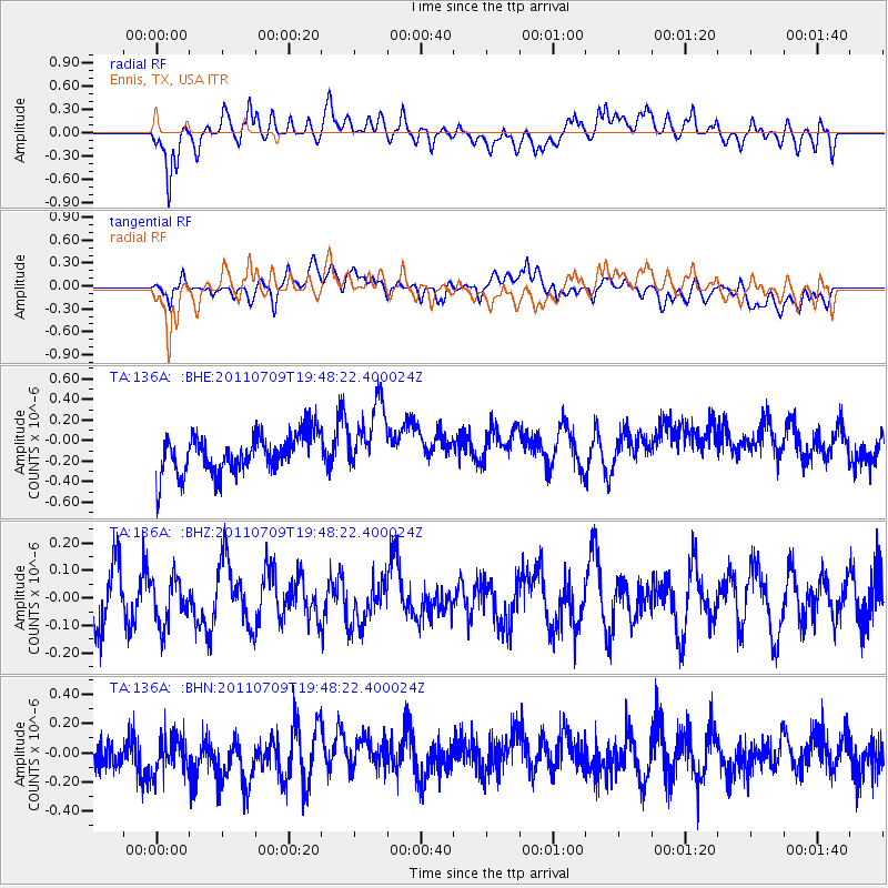
136A Ennis, TX, USA - Earthquake Result Viewer
*The percent match for this event was below the threshold and hence no stack was calculated.
| Earthquake location: |
Kermadec Islands, New Zealand |
| Earthquake latitude/longitude: |
-29.4/-177.0 |
| Earthquake time(UTC): |
2011/07/09 (190) 19:35:18 GMT |
| Earthquake Depth: |
15 km |
| Earthquake Magnitude: |
5.5 MB, 5.8 MS, 5.9 MW, 5.7 MW |
| Earthquake Catalog/Contributor: |
WHDF/NEIC |
|
| Network: |
TA USArray Transportable Network (new EarthScope stations) |
| Station: |
136A Ennis, TX, USA |
| Lat/Lon: |
32.47 N/96.53 W |
| Elevation: |
113 m |
|
| Distance: |
98.0 deg |
| Az: |
57.332 deg |
| Baz: |
240.315 deg |
| Ray Param: |
$rayparam |
*The percent match for this event was below the threshold and hence was not used in the summary stack. |
|
| Radial Match: |
61.143333 % |
| Radial Bump: |
400 |
| Transverse Match: |
25.675901 % |
| Transverse Bump: |
400 |
| SOD ConfigId: |
395004 |
| Insert Time: |
2011-12-16 05:31:10.407 +0000 |
| GWidth: |
2.5 |
| Max Bumps: |
400 |
| Tol: |
0.001 |
|
Signal To Noise
| Channel | StoN | STA | LTA |
| TA:136A: :BHZ:20110709T19:48:22.400024Z | 0.866242 | 8.144864E-8 | 9.4025275E-8 |
| TA:136A: :BHN:20110709T19:48:22.400024Z | 0.8725234 | 1.9147733E-7 | 2.1945236E-7 |
| TA:136A: :BHE:20110709T19:48:22.400024Z | 1.8316904 | 3.4360292E-7 | 1.8758789E-7 |
| Arrivals |
| Ps | |
| PpPs | |
| PsPs/PpSs | |


