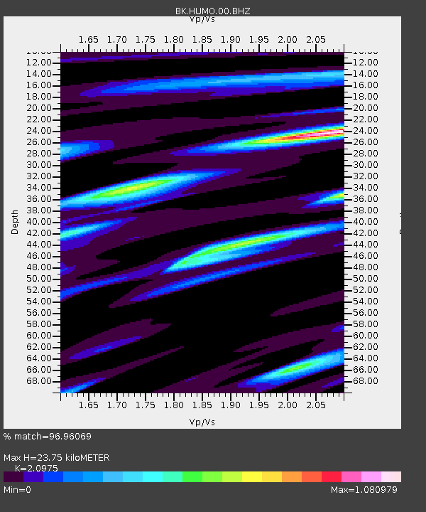
HUMO Hull Mountain, OR - Earthquake Result Viewer
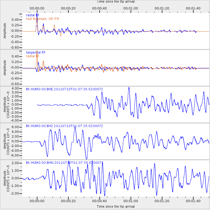
Earthquake location: Off East Coast Of Honshu, Japan
Earthquake latitude/longitude: 38.0/143.3
Earthquake time(UTC): 2011/07/10 (191) 00:57:10 GMT
Earthquake Depth: 23 km
Earthquake Magnitude: 6.6 MB, 7.0 MS, 7.0 MW, 7.0 MW
Earthquake Catalog/Contributor: WHDF/NEIC
Network: BK Berkeley Digital Seismograph Network
Station: HUMO Hull Mountain, OR
Lat/Lon: 42.61 N/122.96 W
Elevation: 555 m
Distance: 67.9 deg
Az: 52.637 deg
Baz: 301.776 deg
Ray Param: 0.05659543
Estimated Moho Depth: 23.75 km
Estimated Crust Vp/Vs: 2.10
Assumed Crust Vp: 6.522 km/s
Estimated Crust Vs: 3.109 km/s
Estimated Crust Poisson's Ratio: 0.35
Radial Match: 96.96069 %
Radial Bump: 400
Transverse Match: 88.98359 %
Transverse Bump: 400
SOD ConfigId: 395004
Insert Time: 2011-12-16 05:47:51.331 +0000
GWidth: 2.5
Max Bumps: 400
Tol: 0.001

Signal To Noise

ChannelStoNSTALTA
BK:HUMO:00:BHZ:20110710T01:07:36.620007Z11.1670879.138104E-78.183069E-8
BK:HUMO:00:BHN:20110710T01:07:36.620007Z1.57047591.7605167E-71.1210084E-7
BK:HUMO:00:BHE:20110710T01:07:36.620007Z4.59264333.6947327E-78.0448935E-8
Arrivals
Ps4.1 SECOND
PpPs11 SECOND
PsPs/PpSs15 SECOND