You are here: Home > Network List > CI - Caltech Regional Seismic Network Stations List
> Station SWS Sam W. Stewart, Westmorland, CA, USA > Earthquake Result Viewer
SWS Sam W. Stewart, Westmorland, CA, USA - Earthquake Result Viewer
| Earthquake location: |
Off East Coast Of Honshu, Japan |
| Earthquake latitude/longitude: |
38.0/143.3 |
| Earthquake time(UTC): |
2011/07/10 (191) 00:57:10 GMT |
| Earthquake Depth: |
23 km |
| Earthquake Magnitude: |
6.6 MB, 7.0 MS, 7.0 MW, 7.0 MW |
| Earthquake Catalog/Contributor: |
WHDF/NEIC |
|
| Network: |
CI Caltech Regional Seismic Network |
| Station: |
SWS Sam W. Stewart, Westmorland, CA, USA |
| Lat/Lon: |
32.94 N/115.80 W |
| Elevation: |
140 m |
|
| Distance: |
78.1 deg |
| Az: |
57.534 deg |
| Baz: |
307.599 deg |
| Ray Param: |
0.049840298 |
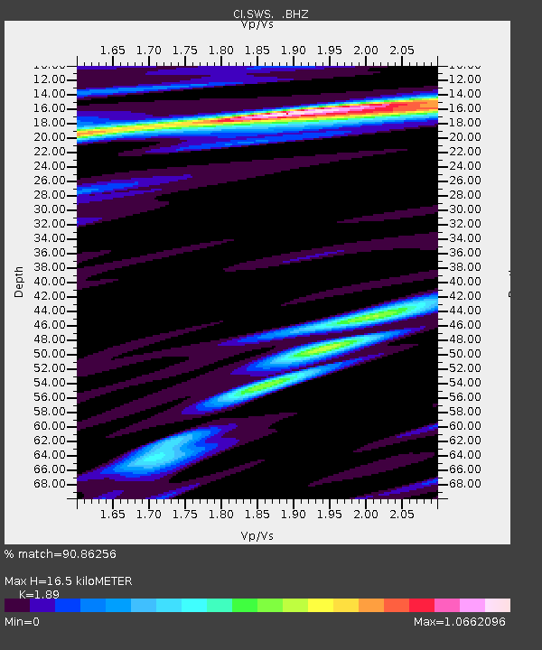
| Estimated Moho Depth: |
16.5 km |
| Estimated Crust Vp/Vs: |
1.89 |
| Assumed Crust Vp: |
6.155 km/s |
| Estimated Crust Vs: |
3.256 km/s |
| Estimated Crust Poisson's Ratio: |
0.31 |
|
| Radial Match: |
90.86256 % |
| Radial Bump: |
400 |
| Transverse Match: |
78.25403 % |
| Transverse Bump: |
400 |
| SOD ConfigId: |
395004 |
| Insert Time: |
2011-12-16 05:50:39.914 +0000 |
| GWidth: |
2.5 |
| Max Bumps: |
400 |
| Tol: |
0.001 |
|
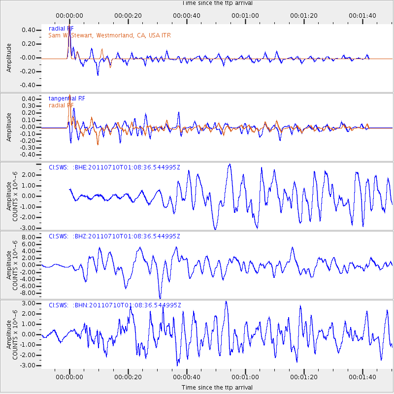
Signal To Noise
| Channel | StoN | STA | LTA |
| CI:SWS: :BHZ:20110710T01:08:36.544995Z | 4.355638 | 8.693644E-7 | 1.9959519E-7 |
| CI:SWS: :BHN:20110710T01:08:36.544995Z | 1.4968882 | 3.258173E-7 | 2.176631E-7 |
| CI:SWS: :BHE:20110710T01:08:36.544995Z | 2.4286149 | 5.877534E-7 | 2.4201177E-7 |
| Arrivals |
| Ps | 2.4 SECOND |
| PpPs | 7.6 SECOND |
| PsPs/PpSs | 10.0 SECOND |


