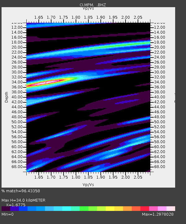
MPM Manuel Prospect Mine, California, USA - Earthquake Result Viewer
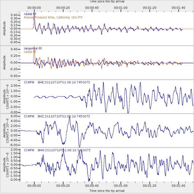
Earthquake location: Off East Coast Of Honshu, Japan
Earthquake latitude/longitude: 38.0/143.3
Earthquake time(UTC): 2011/07/10 (191) 00:57:10 GMT
Earthquake Depth: 23 km
Earthquake Magnitude: 6.6 MB, 7.0 MS, 7.0 MW, 7.0 MW
Earthquake Catalog/Contributor: WHDF/NEIC
Network: CI Caltech Regional Seismic Network
Station: MPM Manuel Prospect Mine, California, USA
Lat/Lon: 36.06 N/117.49 W
Elevation: 185 m
Distance: 75.1 deg
Az: 55.843 deg
Baz: 306.253 deg
Ray Param: 0.051852524
Estimated Moho Depth: 34.0 km
Estimated Crust Vp/Vs: 1.68
Assumed Crust Vp: 6.279 km/s
Estimated Crust Vs: 3.743 km/s
Estimated Crust Poisson's Ratio: 0.22
Radial Match: 96.43358 %
Radial Bump: 400
Transverse Match: 90.58666 %
Transverse Bump: 400
SOD ConfigId: 395004
Insert Time: 2011-12-16 05:50:50.596 +0000
GWidth: 2.5
Max Bumps: 400
Tol: 0.001

Signal To Noise

ChannelStoNSTALTA
CI:MPM: :BHZ:20110710T01:08:19.745007Z5.32936336.960865E-71.3061344E-7
CI:MPM: :BHN:20110710T01:08:19.745007Z2.29251481.5146065E-76.606747E-8
CI:MPM: :BHE:20110710T01:08:19.745007Z2.51673442.8689126E-71.1399346E-7
Arrivals
Ps3.8 SECOND
PpPs14 SECOND
PsPs/PpSs18 SECOND