You are here: Home > Network List > CI - Caltech Regional Seismic Network Stations List
> Station CIA CIA, Avalon Catalina Island, CA, USA > Earthquake Result Viewer
CIA CIA, Avalon Catalina Island, CA, USA - Earthquake Result Viewer
| Earthquake location: |
Off East Coast Of Honshu, Japan |
| Earthquake latitude/longitude: |
38.0/143.3 |
| Earthquake time(UTC): |
2011/07/10 (191) 00:57:10 GMT |
| Earthquake Depth: |
23 km |
| Earthquake Magnitude: |
6.6 MB, 7.0 MS, 7.0 MW, 7.0 MW |
| Earthquake Catalog/Contributor: |
WHDF/NEIC |
|
| Network: |
CI Caltech Regional Seismic Network |
| Station: |
CIA CIA, Avalon Catalina Island, CA, USA |
| Lat/Lon: |
33.40 N/118.41 W |
| Elevation: |
467 m |
|
| Distance: |
76.1 deg |
| Az: |
58.513 deg |
| Baz: |
306.392 deg |
| Ray Param: |
0.051210217 |
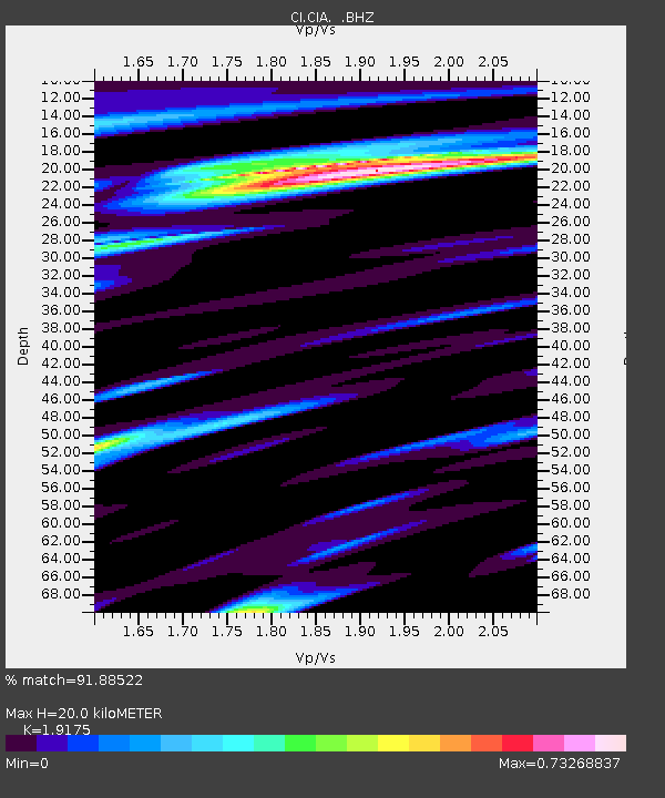
| Estimated Moho Depth: |
20.0 km |
| Estimated Crust Vp/Vs: |
1.92 |
| Assumed Crust Vp: |
6.048 km/s |
| Estimated Crust Vs: |
3.154 km/s |
| Estimated Crust Poisson's Ratio: |
0.31 |
|
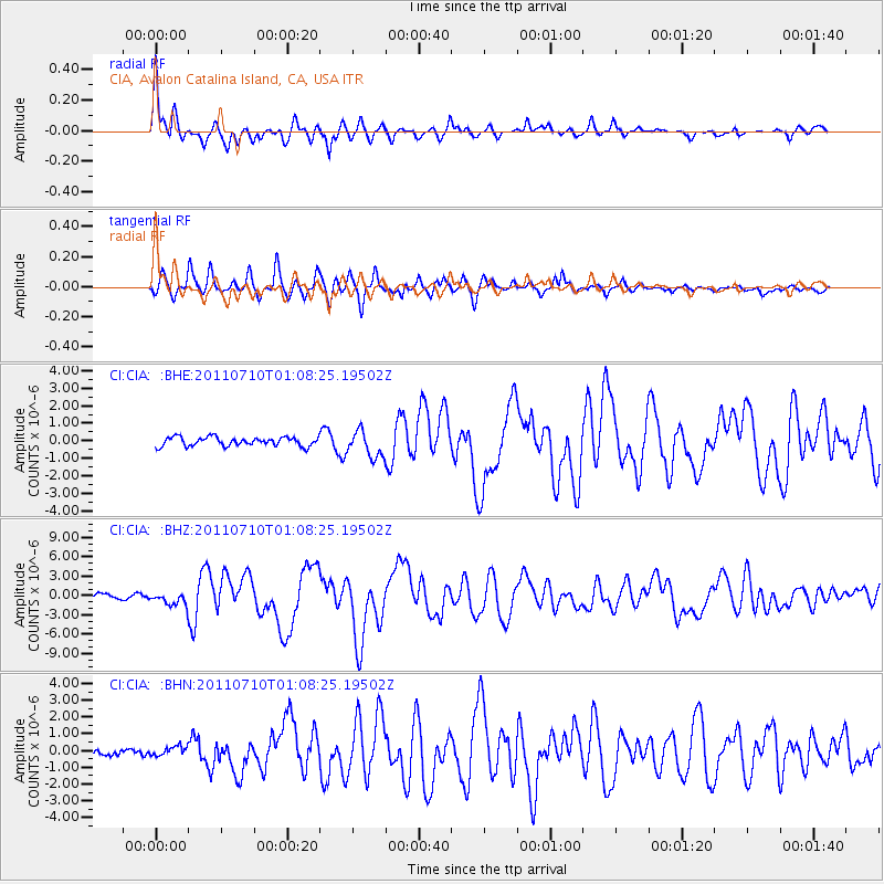
| Radial Match: |
91.88522 % |
| Radial Bump: |
399 |
| Transverse Match: |
87.9677 % |
| Transverse Bump: |
400 |
| SOD ConfigId: |
395004 |
| Insert Time: |
2011-12-16 05:50:54.569 +0000 |
| GWidth: |
2.5 |
| Max Bumps: |
400 |
| Tol: |
0.001 |
|
Signal To Noise
| Channel | StoN | STA | LTA |
| CI:CIA: :BHZ:20110710T01:08:25.19502Z | 3.3939836 | 9.766019E-7 | 2.8774502E-7 |
| CI:CIA: :BHN:20110710T01:08:25.19502Z | 1.0876852 | 2.693284E-7 | 2.4761613E-7 |
| CI:CIA: :BHE:20110710T01:08:25.19502Z | 2.9837332 | 7.517551E-7 | 2.5195118E-7 |
| Arrivals |
| Ps | 3.1 SECOND |
| PpPs | 9.4 SECOND |
| PsPs/PpSs | 13 SECOND |


