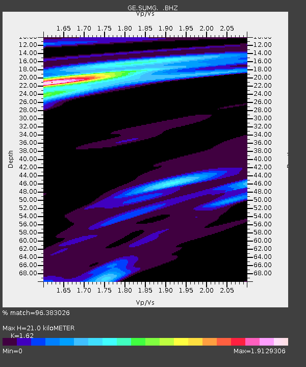
SUMG GEOFON Station Summit Camp, Greenland - Earthquake Result Viewer

Earthquake location: Off East Coast Of Honshu, Japan
Earthquake latitude/longitude: 38.0/143.3
Earthquake time(UTC): 2011/07/10 (191) 00:57:10 GMT
Earthquake Depth: 23 km
Earthquake Magnitude: 6.6 MB, 7.0 MS, 7.0 MW, 7.0 MW
Earthquake Catalog/Contributor: WHDF/NEIC
Network: GE GEOFON
Station: SUMG GEOFON Station Summit Camp, Greenland
Lat/Lon: 72.58 N/38.45 W
Elevation: 3240 m
Distance: 69.7 deg
Az: 0.552 deg
Baz: 358.553 deg
Ray Param: 0.05545891
Estimated Moho Depth: 21.0 km
Estimated Crust Vp/Vs: 1.62
Assumed Crust Vp: 6.261 km/s
Estimated Crust Vs: 3.865 km/s
Estimated Crust Poisson's Ratio: 0.19
Radial Match: 96.383026 %
Radial Bump: 400
Transverse Match: 88.13542 %
Transverse Bump: 400
SOD ConfigId: 395004
Insert Time: 2011-12-16 06:14:17.209 +0000
GWidth: 2.5
Max Bumps: 400
Tol: 0.001

Signal To Noise

ChannelStoNSTALTA
GE:SUMG: :BHZ:20110710T01:07:47.394971Z9.30277251.8634518E-62.0031145E-7
GE:SUMG: :BHN:20110710T01:07:47.394971Z2.5169374.1798262E-71.6606798E-7
GE:SUMG: :BHE:20110710T01:07:47.394971Z1.11460461.0776826E-79.6687444E-8
Arrivals
Ps2.2 SECOND
PpPs8.5 SECOND
PsPs/PpSs11 SECOND