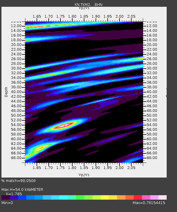
TKM2 KN.TKM2 - Earthquake Result Viewer
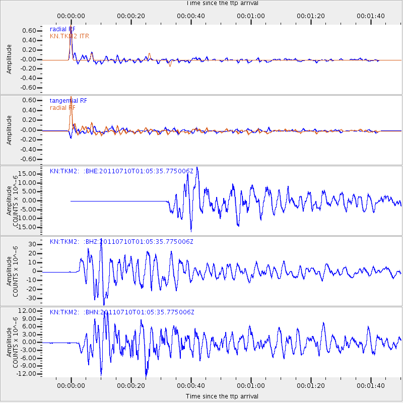
Earthquake location: Off East Coast Of Honshu, Japan
Earthquake latitude/longitude: 38.0/143.3
Earthquake time(UTC): 2011/07/10 (191) 00:57:10 GMT
Earthquake Depth: 23 km
Earthquake Magnitude: 6.6 MB, 7.0 MS, 7.0 MW, 7.0 MW
Earthquake Catalog/Contributor: WHDF/NEIC
Network: KN Kyrgyz Seismic Telemetry Network
Station: TKM2 KN.TKM2
Lat/Lon: 42.92 N/75.60 E
Elevation: 2020 m
Distance: 50.5 deg
Az: 298.214 deg
Baz: 71.309 deg
Ray Param: 0.06801325
Estimated Moho Depth: 54.0 km
Estimated Crust Vp/Vs: 1.76
Assumed Crust Vp: 6.306 km/s
Estimated Crust Vs: 3.573 km/s
Estimated Crust Poisson's Ratio: 0.26
Radial Match: 98.0508 %
Radial Bump: 372
Transverse Match: 93.66045 %
Transverse Bump: 400
SOD ConfigId: 395004
Insert Time: 2011-12-16 06:18:21.333 +0000
GWidth: 2.5
Max Bumps: 400
Tol: 0.001

Signal To Noise

ChannelStoNSTALTA
KN:TKM2: :BHZ:20110710T01:05:35.775006Z98.5537956.282523E-66.3747144E-8
KN:TKM2: :BHN:20110710T01:05:35.775006Z50.4520031.4388211E-62.8518611E-8
KN:TKM2: :BHE:20110710T01:05:35.775006Z52.001352.797647E-65.3799507E-8
Arrivals
Ps6.9 SECOND
PpPs22 SECOND
PsPs/PpSs29 SECOND