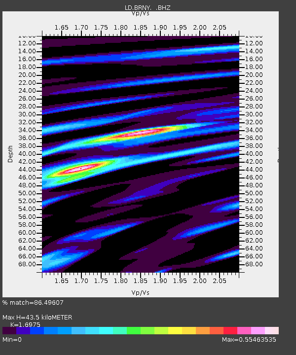
BRNY Black Rock Forest, Cornwall, NY - Earthquake Result Viewer

Earthquake location: Off East Coast Of Honshu, Japan
Earthquake latitude/longitude: 38.0/143.3
Earthquake time(UTC): 2011/07/10 (191) 00:57:10 GMT
Earthquake Depth: 23 km
Earthquake Magnitude: 6.6 MB, 7.0 MS, 7.0 MW, 7.0 MW
Earthquake Catalog/Contributor: WHDF/NEIC
Network: LD Lamont-Doherty Cooperative Seismographic Network
Station: BRNY Black Rock Forest, Cornwall, NY
Lat/Lon: 41.41 N/74.01 W
Elevation: 248 m
Distance: 93.9 deg
Az: 27.168 deg
Baz: 331.356 deg
Ray Param: 0.041157737
Estimated Moho Depth: 43.5 km
Estimated Crust Vp/Vs: 1.70
Assumed Crust Vp: 6.283 km/s
Estimated Crust Vs: 3.702 km/s
Estimated Crust Poisson's Ratio: 0.23
Radial Match: 86.49607 %
Radial Bump: 294
Transverse Match: 65.424774 %
Transverse Bump: 400
SOD ConfigId: 395004
Insert Time: 2011-12-16 06:20:01.932 +0000
GWidth: 2.5
Max Bumps: 400
Tol: 0.001

Signal To Noise

ChannelStoNSTALTA
LD:BRNY: :BHZ:20110710T01:09:54.875989Z2.91856074.5790617E-71.5689452E-7
LD:BRNY: :BHN:20110710T01:09:54.875989Z1.09729972.2393829E-72.0408125E-7
LD:BRNY: :BHE:20110710T01:09:54.875989Z0.60474471.0537557E-71.7424803E-7
Arrivals
Ps4.9 SECOND
PpPs18 SECOND
PsPs/PpSs23 SECOND