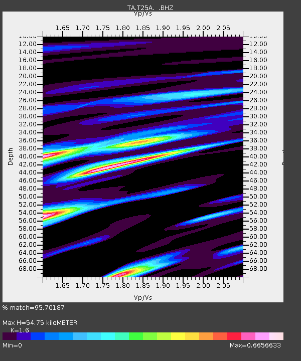
T25A Trinidad, CO, USA - Earthquake Result Viewer

Earthquake location: Off East Coast Of Honshu, Japan
Earthquake latitude/longitude: 38.0/143.3
Earthquake time(UTC): 2011/07/10 (191) 00:57:10 GMT
Earthquake Depth: 23 km
Earthquake Magnitude: 6.6 MB, 7.0 MS, 7.0 MW, 7.0 MW
Earthquake Catalog/Contributor: WHDF/NEIC
Network: TA USArray Transportable Network (new EarthScope stations)
Station: T25A Trinidad, CO, USA
Lat/Lon: 37.14 N/104.41 W
Elevation: 2017 m
Distance: 82.6 deg
Az: 48.199 deg
Baz: 312.555 deg
Ray Param: 0.04676541
Estimated Moho Depth: 54.75 km
Estimated Crust Vp/Vs: 1.60
Assumed Crust Vp: 6.316 km/s
Estimated Crust Vs: 3.947 km/s
Estimated Crust Poisson's Ratio: 0.18
Radial Match: 95.70187 %
Radial Bump: 399
Transverse Match: 93.8043 %
Transverse Bump: 400
SOD ConfigId: 395004
Insert Time: 2011-12-16 06:25:59.133 +0000
GWidth: 2.5
Max Bumps: 400
Tol: 0.001

Signal To Noise

ChannelStoNSTALTA
TA:T25A: :BHZ:20110710T01:09:00.524976Z12.4217278.455201E-76.8067834E-8
TA:T25A: :BHN:20110710T01:09:00.524976Z5.21349763.0432082E-75.8371718E-8
TA:T25A: :BHE:20110710T01:09:00.524976Z2.47237751.4915221E-76.0327444E-8
Arrivals
Ps5.3 SECOND
PpPs22 SECOND
PsPs/PpSs27 SECOND