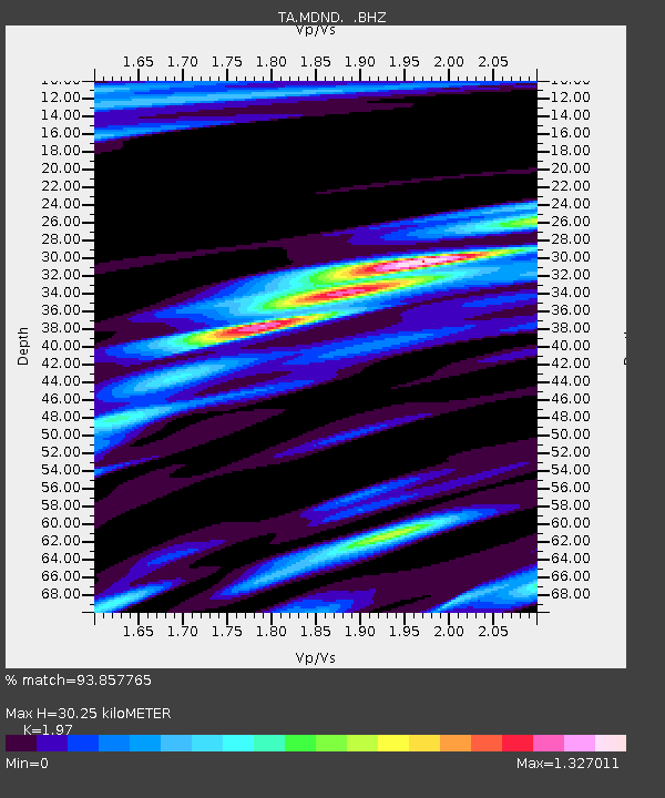
MDND Maddock, ND, USA - Earthquake Result Viewer
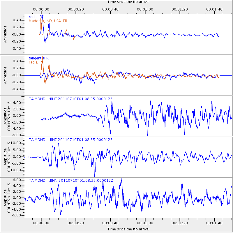
Earthquake location: Off East Coast Of Honshu, Japan
Earthquake latitude/longitude: 38.0/143.3
Earthquake time(UTC): 2011/07/10 (191) 00:57:10 GMT
Earthquake Depth: 23 km
Earthquake Magnitude: 6.6 MB, 7.0 MS, 7.0 MW, 7.0 MW
Earthquake Catalog/Contributor: WHDF/NEIC
Network: TA USArray Transportable Network (new EarthScope stations)
Station: MDND Maddock, ND, USA
Lat/Lon: 47.85 N/99.60 W
Elevation: 479 m
Distance: 77.8 deg
Az: 37.824 deg
Baz: 314.035 deg
Ray Param: 0.050035052
Estimated Moho Depth: 30.25 km
Estimated Crust Vp/Vs: 1.97
Assumed Crust Vp: 6.53 km/s
Estimated Crust Vs: 3.315 km/s
Estimated Crust Poisson's Ratio: 0.33
Radial Match: 93.857765 %
Radial Bump: 382
Transverse Match: 65.11803 %
Transverse Bump: 400
SOD ConfigId: 395004
Insert Time: 2011-12-16 06:26:28.963 +0000
GWidth: 2.5
Max Bumps: 400
Tol: 0.001

Signal To Noise

ChannelStoNSTALTA
TA:MDND: :BHZ:20110710T01:08:35.000012Z14.6624712.1593858E-61.4727297E-7
TA:MDND: :BHN:20110710T01:08:35.000012Z1.20918299.397145E-77.7714833E-7
TA:MDND: :BHE:20110710T01:08:35.000012Z0.878896065.013126E-75.70389E-7
Arrivals
Ps4.6 SECOND
PpPs13 SECOND
PsPs/PpSs18 SECOND