TUL1 Leonard, OK, USA - Earthquake Result Viewer
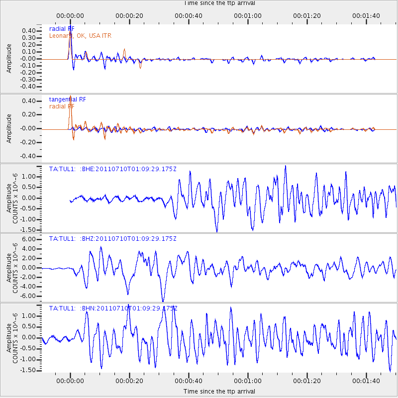
Earthquake location: Off East Coast Of Honshu, Japan
Earthquake latitude/longitude: 38.0/143.3
Earthquake time(UTC): 2011/07/10 (191) 00:57:10 GMT
Earthquake Depth: 23 km
Earthquake Magnitude: 6.6 MB, 7.0 MS, 7.0 MW, 7.0 MW
Earthquake Catalog/Contributor: WHDF/NEIC
Network: TA USArray Transportable Network (new EarthScope stations)
Station: TUL1 Leonard, OK, USA
Lat/Lon: 35.91 N/95.79 W
Elevation: 256 m
Distance: 88.4 deg
Az: 44.15 deg
Baz: 317.349 deg
Ray Param: 0.042623237
Estimated Moho Depth: 10.75 km
Estimated Crust Vp/Vs: 2.10
Assumed Crust Vp: 6.498 km/s
Estimated Crust Vs: 3.098 km/s
Estimated Crust Poisson's Ratio: 0.35
Radial Match: 95.99873 %
Radial Bump: 400
Transverse Match: 79.09511 %
Transverse Bump: 400
SOD ConfigId: 395004
Insert Time: 2011-12-16 06:26:51.597 +0000
GWidth: 2.5
Max Bumps: 400
Tol: 0.001

Signal To Noise

ChannelStoNSTALTA
TA:TUL1: :BHZ:20110710T01:09:29.175Z10.1068628.3224467E-78.234451E-8
TA:TUL1: :BHN:20110710T01:09:29.175Z1.82853641.8469387E-71.010064E-7
TA:TUL1: :BHE:20110710T01:09:29.175Z1.87744981.6337951E-78.702204E-8
Arrivals
Ps1.9 SECOND
PpPs5.0 SECOND
PsPs/PpSs6.9 SECOND