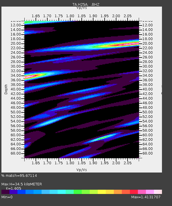
H25A Fruitdale, SD, USA - Earthquake Result Viewer
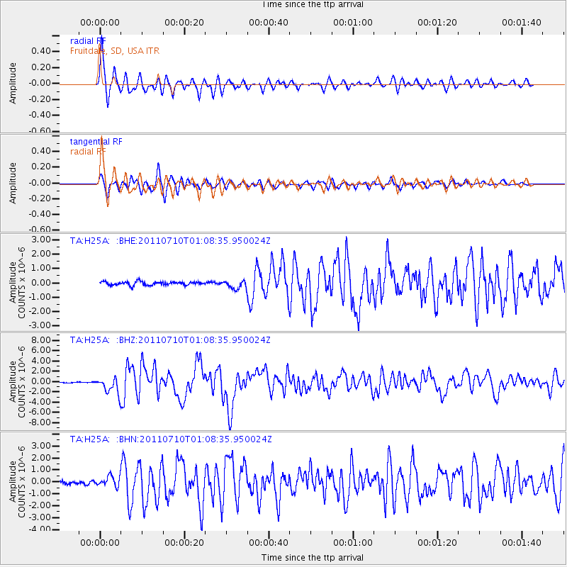
Earthquake location: Off East Coast Of Honshu, Japan
Earthquake latitude/longitude: 38.0/143.3
Earthquake time(UTC): 2011/07/10 (191) 00:57:10 GMT
Earthquake Depth: 23 km
Earthquake Magnitude: 6.6 MB, 7.0 MS, 7.0 MW, 7.0 MW
Earthquake Catalog/Contributor: WHDF/NEIC
Network: TA USArray Transportable Network (new EarthScope stations)
Station: H25A Fruitdale, SD, USA
Lat/Lon: 44.62 N/103.60 W
Elevation: 942 m
Distance: 78.0 deg
Az: 42.171 deg
Baz: 312.068 deg
Ray Param: 0.04991546
Estimated Moho Depth: 34.5 km
Estimated Crust Vp/Vs: 1.61
Assumed Crust Vp: 6.242 km/s
Estimated Crust Vs: 3.889 km/s
Estimated Crust Poisson's Ratio: 0.18
Radial Match: 95.67114 %
Radial Bump: 391
Transverse Match: 89.73194 %
Transverse Bump: 400
SOD ConfigId: 395004
Insert Time: 2011-12-16 06:27:19.751 +0000
GWidth: 2.5
Max Bumps: 400
Tol: 0.001

Signal To Noise

ChannelStoNSTALTA
TA:H25A: :BHZ:20110710T01:08:35.950024Z21.6656861.6191877E-67.473513E-8
TA:H25A: :BHN:20110710T01:08:35.950024Z3.37388044.4318807E-71.3135856E-7
TA:H25A: :BHE:20110710T01:08:35.950024Z2.51964263.0569333E-71.2132408E-7
Arrivals
Ps3.5 SECOND
PpPs14 SECOND
PsPs/PpSs17 SECOND