You are here: Home > Network List > TA - USArray Transportable Network (new EarthScope stations) Stations List
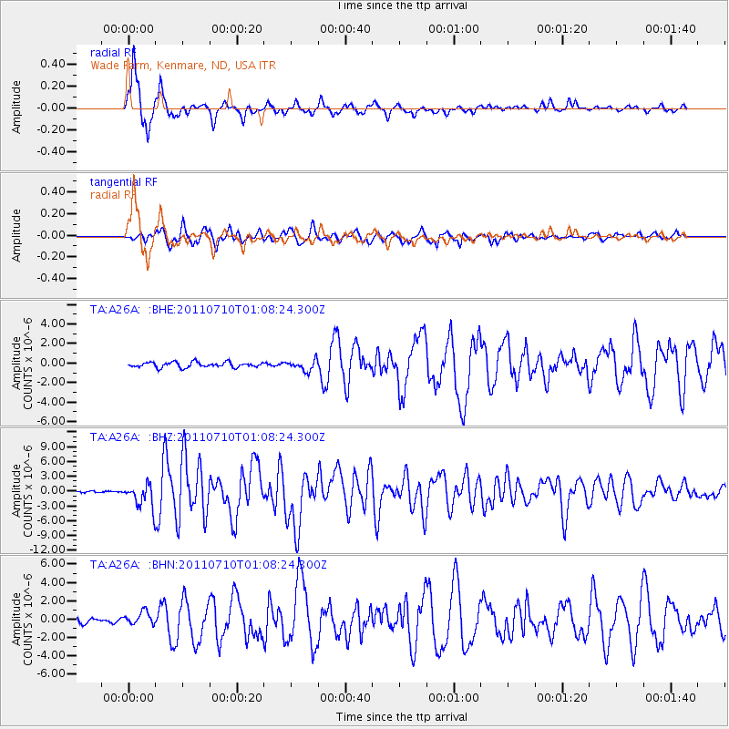
> Station A26A Wade Farm, Kenmare, ND, USA > Earthquake Result Viewer
A26A Wade Farm, Kenmare, ND, USA - Earthquake Result Viewer
| Earthquake location: |
Off East Coast Of Honshu, Japan |
| Earthquake latitude/longitude: |
38.0/143.3 |
| Earthquake time(UTC): |
2011/07/10 (191) 00:57:10 GMT |
| Earthquake Depth: |
23 km |
| Earthquake Magnitude: |
6.6 MB, 7.0 MS, 7.0 MW, 7.0 MW |
| Earthquake Catalog/Contributor: |
WHDF/NEIC |
|
| Network: |
TA USArray Transportable Network (new EarthScope stations) |
| Station: |
A26A Wade Farm, Kenmare, ND, USA |
| Lat/Lon: |
48.90 N/102.04 W |
| Elevation: |
570 m |
|
| Distance: |
75.9 deg |
| Az: |
38.179 deg |
| Baz: |
312.3 deg |
| Ray Param: |
0.051317077 |
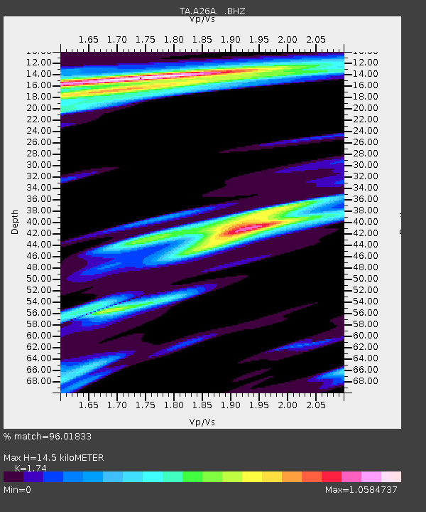
| Estimated Moho Depth: |
14.5 km |
| Estimated Crust Vp/Vs: |
1.74 |
| Assumed Crust Vp: |
6.438 km/s |
| Estimated Crust Vs: |
3.7 km/s |
| Estimated Crust Poisson's Ratio: |
0.25 |
|
| Radial Match: |
96.01833 % |
| Radial Bump: |
309 |
| Transverse Match: |
90.297356 % |
| Transverse Bump: |
400 |
| SOD ConfigId: |
395004 |
| Insert Time: |
2011-12-16 06:27:33.550 +0000 |
| GWidth: |
2.5 |
| Max Bumps: |
400 |
| Tol: |
0.001 |
|
Signal To Noise
| Channel | StoN | STA | LTA |
| TA:A26A: :BHZ:20110710T01:08:24.300Z | 13.851343 | 2.4329447E-6 | 1.7564685E-7 |
| TA:A26A: :BHN:20110710T01:08:24.300Z | 3.6606555 | 7.2224736E-7 | 1.9730003E-7 |
| TA:A26A: :BHE:20110710T01:08:24.300Z | 2.0210164 | 5.359582E-7 | 2.651924E-7 |
| Arrivals |
| Ps | 1.7 SECOND |
| PpPs | 6.0 SECOND |
| PsPs/PpSs | 7.7 SECOND |


