You are here: Home > Network List > TA - USArray Transportable Network (new EarthScope stations) Stations List
> Station A30A Hoffart Farm, Langdon, ND, USA > Earthquake Result Viewer
A30A Hoffart Farm, Langdon, ND, USA - Earthquake Result Viewer

| Earthquake location: |
Off East Coast Of Honshu, Japan |
| Earthquake latitude/longitude: |
38.0/143.3 |
| Earthquake time(UTC): |
2011/07/10 (191) 00:57:10 GMT |
| Earthquake Depth: |
23 km |
| Earthquake Magnitude: |
6.6 MB, 7.0 MS, 7.0 MW, 7.0 MW |
| Earthquake Catalog/Contributor: |
WHDF/NEIC |
|
| Network: |
TA USArray Transportable Network (new EarthScope stations) |
| Station: |
A30A Hoffart Farm, Langdon, ND, USA |
| Lat/Lon: |
48.94 N/98.30 W |
| Elevation: |
484 m |
|
| Distance: |
77.7 deg |
| Az: |
36.404 deg |
| Baz: |
314.704 deg |
| Ray Param: |
0.050133027 |
| Estimated Moho Depth: |
24.75 km |
| Estimated Crust Vp/Vs: |
1.71 |
| Assumed Crust Vp: |
6.53 km/s |
| Estimated Crust Vs: |
3.819 km/s |
| Estimated Crust Poisson's Ratio: |
0.24 |
|
| Radial Match: |
96.82405 % |
| Radial Bump: |
400 |
| Transverse Match: |
92.72447 % |
| Transverse Bump: |
400 |
| SOD ConfigId: |
395004 |
| Insert Time: |
2011-12-16 06:28:41.831 +0000 |
| GWidth: |
2.5 |
| Max Bumps: |
400 |
| Tol: |
0.001 |
|
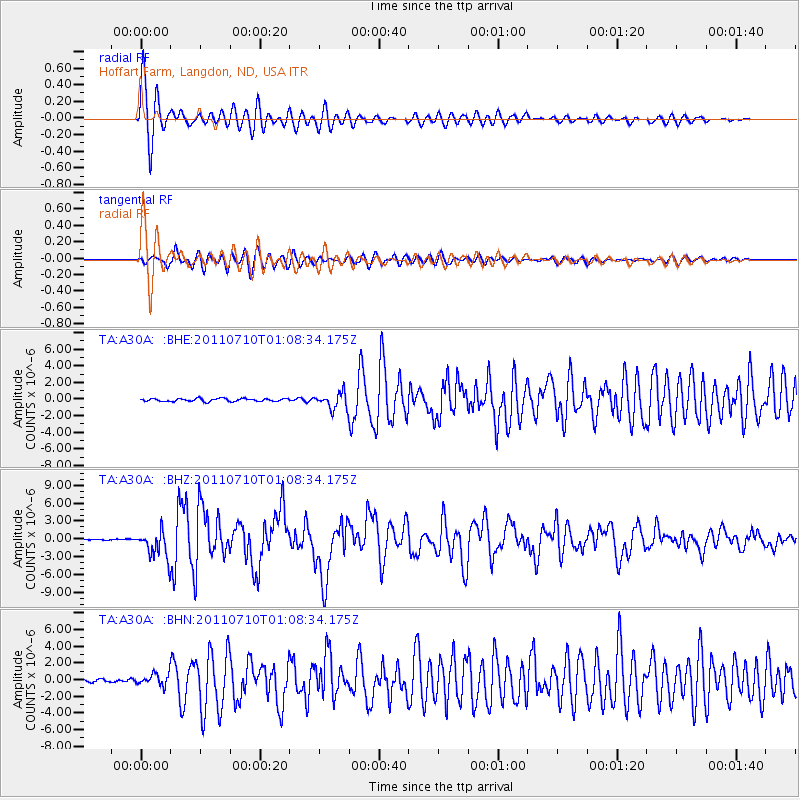
Signal To Noise
| Channel | StoN | STA | LTA |
| TA:A30A: :BHZ:20110710T01:08:34.175Z | 26.66158 | 2.3321645E-6 | 8.7472856E-8 |
| TA:A30A: :BHN:20110710T01:08:34.175Z | 5.5087776 | 6.934195E-7 | 1.2587539E-7 |
| TA:A30A: :BHE:20110710T01:08:34.175Z | 5.533128 | 9.706181E-7 | 1.7541943E-7 |
| Arrivals |
| Ps | 2.8 SECOND |
| PpPs | 9.9 SECOND |
| PsPs/PpSs | 13 SECOND |


