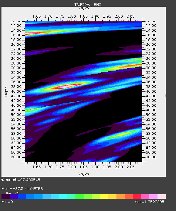
F29A Eureka, SD, USA - Earthquake Result Viewer
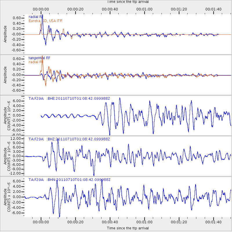
Earthquake location: Off East Coast Of Honshu, Japan
Earthquake latitude/longitude: 38.0/143.3
Earthquake time(UTC): 2011/07/10 (191) 00:57:10 GMT
Earthquake Depth: 23 km
Earthquake Magnitude: 6.6 MB, 7.0 MS, 7.0 MW, 7.0 MW
Earthquake Catalog/Contributor: WHDF/NEIC
Network: TA USArray Transportable Network (new EarthScope stations)
Station: F29A Eureka, SD, USA
Lat/Lon: 45.83 N/99.83 W
Elevation: 575 m
Distance: 79.1 deg
Az: 39.411 deg
Baz: 314.188 deg
Ray Param: 0.049157016
Estimated Moho Depth: 37.5 km
Estimated Crust Vp/Vs: 1.79
Assumed Crust Vp: 6.53 km/s
Estimated Crust Vs: 3.648 km/s
Estimated Crust Poisson's Ratio: 0.27
Radial Match: 97.480545 %
Radial Bump: 313
Transverse Match: 89.41924 %
Transverse Bump: 400
SOD ConfigId: 395004
Insert Time: 2011-12-16 06:28:55.979 +0000
GWidth: 2.5
Max Bumps: 400
Tol: 0.001

Signal To Noise

ChannelStoNSTALTA
TA:F29A: :BHZ:20110710T01:08:42.099988Z19.3707282.6783937E-61.3827015E-7
TA:F29A: :BHN:20110710T01:08:42.099988Z2.2653095.118452E-72.2594936E-7
TA:F29A: :BHE:20110710T01:08:42.099988Z1.7406257.641897E-74.3903177E-7
Arrivals
Ps4.7 SECOND
PpPs16 SECOND
PsPs/PpSs20 SECOND