You are here: Home > Network List > TA - USArray Transportable Network (new EarthScope stations) Stations List
> Station T33A Patterson Ranch, Waldron, KS, USA > Earthquake Result Viewer
T33A Patterson Ranch, Waldron, KS, USA - Earthquake Result Viewer
| Earthquake location: |
Off East Coast Of Honshu, Japan |
| Earthquake latitude/longitude: |
38.0/143.3 |
| Earthquake time(UTC): |
2011/07/10 (191) 00:57:10 GMT |
| Earthquake Depth: |
23 km |
| Earthquake Magnitude: |
6.6 MB, 7.0 MS, 7.0 MW, 7.0 MW |
| Earthquake Catalog/Contributor: |
WHDF/NEIC |
|
| Network: |
TA USArray Transportable Network (new EarthScope stations) |
| Station: |
T33A Patterson Ranch, Waldron, KS, USA |
| Lat/Lon: |
37.08 N/98.24 W |
| Elevation: |
394 m |
|
| Distance: |
86.2 deg |
| Az: |
44.785 deg |
| Baz: |
315.927 deg |
| Ray Param: |
0.044233054 |
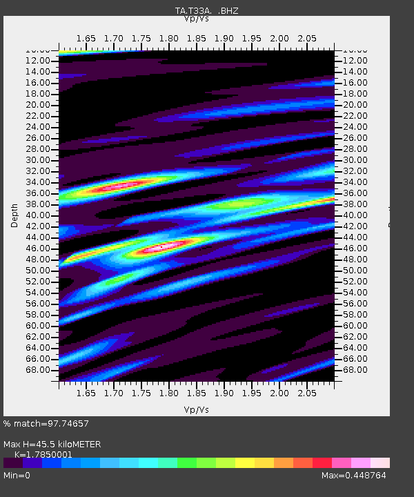
| Estimated Moho Depth: |
45.5 km |
| Estimated Crust Vp/Vs: |
1.79 |
| Assumed Crust Vp: |
6.426 km/s |
| Estimated Crust Vs: |
3.6 km/s |
| Estimated Crust Poisson's Ratio: |
0.27 |
|
| Radial Match: |
97.74657 % |
| Radial Bump: |
302 |
| Transverse Match: |
87.98317 % |
| Transverse Bump: |
400 |
| SOD ConfigId: |
395004 |
| Insert Time: |
2011-12-16 06:30:55.945 +0000 |
| GWidth: |
2.5 |
| Max Bumps: |
400 |
| Tol: |
0.001 |
|
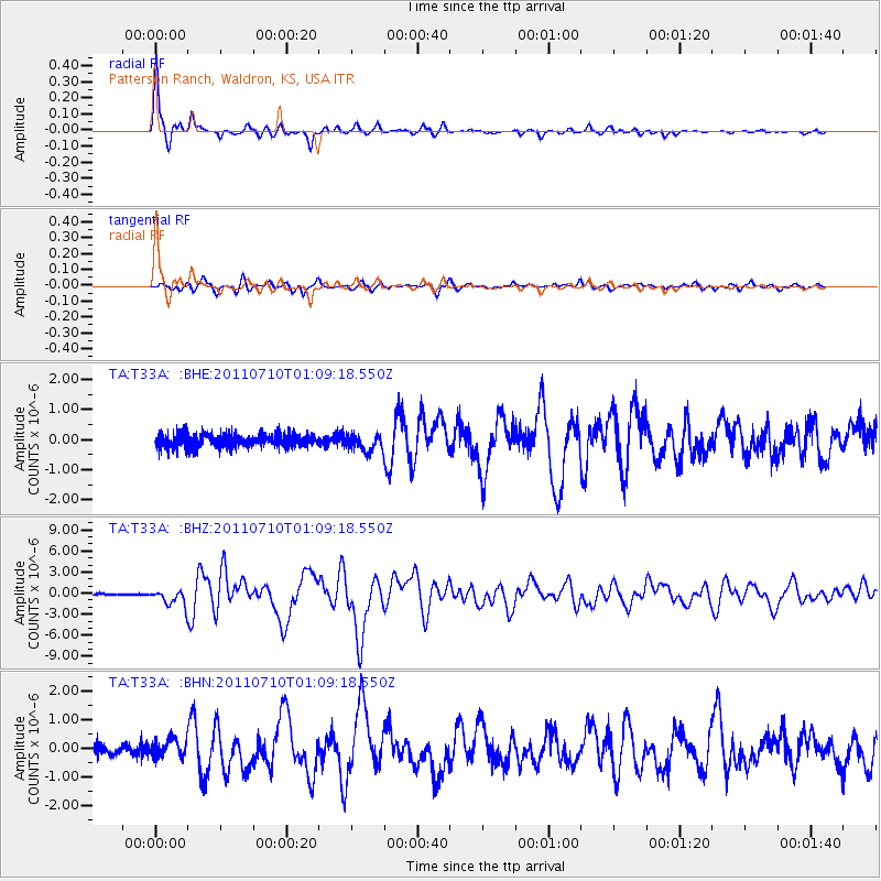
Signal To Noise
| Channel | StoN | STA | LTA |
| TA:T33A: :BHZ:20110710T01:09:18.550Z | 11.342744 | 1.1372493E-6 | 1.00262284E-7 |
| TA:T33A: :BHN:20110710T01:09:18.550Z | 1.5420921 | 2.9881753E-7 | 1.937741E-7 |
| TA:T33A: :BHE:20110710T01:09:18.550Z | 1.3438243 | 2.805314E-7 | 2.0875603E-7 |
| Arrivals |
| Ps | 5.7 SECOND |
| PpPs | 19 SECOND |
| PsPs/PpSs | 25 SECOND |


