You are here: Home > Network List > TA - USArray Transportable Network (new EarthScope stations) Stations List
> Station U32A Winter Ranch, Mooreland, OK, USA > Earthquake Result Viewer
U32A Winter Ranch, Mooreland, OK, USA - Earthquake Result Viewer
| Earthquake location: |
Off East Coast Of Honshu, Japan |
| Earthquake latitude/longitude: |
38.0/143.3 |
| Earthquake time(UTC): |
2011/07/10 (191) 00:57:10 GMT |
| Earthquake Depth: |
23 km |
| Earthquake Magnitude: |
6.6 MB, 7.0 MS, 7.0 MW, 7.0 MW |
| Earthquake Catalog/Contributor: |
WHDF/NEIC |
|
| Network: |
TA USArray Transportable Network (new EarthScope stations) |
| Station: |
U32A Winter Ranch, Mooreland, OK, USA |
| Lat/Lon: |
36.38 N/99.00 W |
| Elevation: |
525 m |
|
| Distance: |
86.2 deg |
| Az: |
45.712 deg |
| Baz: |
315.537 deg |
| Ray Param: |
0.044177856 |
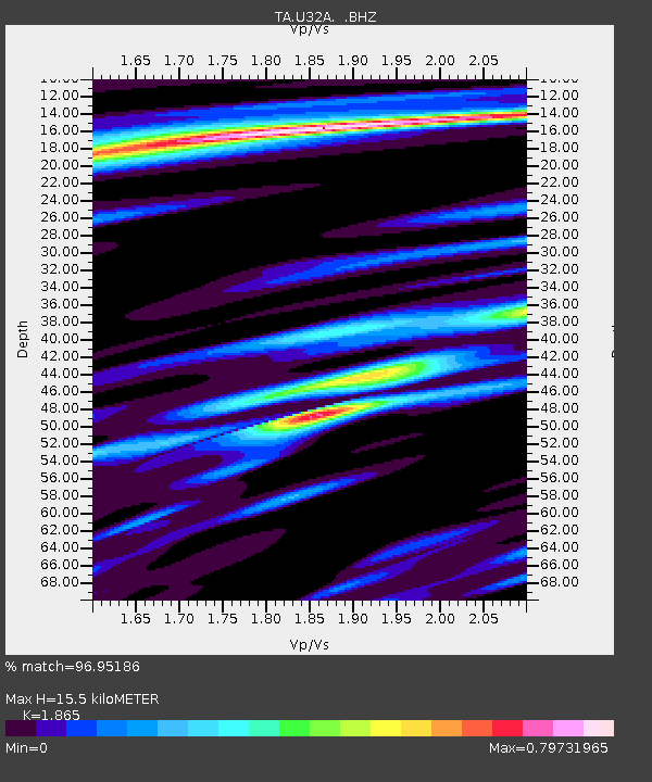
| Estimated Moho Depth: |
15.5 km |
| Estimated Crust Vp/Vs: |
1.87 |
| Assumed Crust Vp: |
6.426 km/s |
| Estimated Crust Vs: |
3.446 km/s |
| Estimated Crust Poisson's Ratio: |
0.30 |
|
| Radial Match: |
96.95186 % |
| Radial Bump: |
345 |
| Transverse Match: |
92.444305 % |
| Transverse Bump: |
366 |
| SOD ConfigId: |
395004 |
| Insert Time: |
2011-12-16 06:31:56.130 +0000 |
| GWidth: |
2.5 |
| Max Bumps: |
400 |
| Tol: |
0.001 |
|

Signal To Noise
| Channel | StoN | STA | LTA |
| TA:U32A: :BHZ:20110710T01:09:18.925Z | 5.125397 | 8.577666E-7 | 1.6735613E-7 |
| TA:U32A: :BHN:20110710T01:09:18.925Z | 2.9985166 | 3.9149646E-7 | 1.3056338E-7 |
| TA:U32A: :BHE:20110710T01:09:18.925Z | 1.0908601 | 1.3251648E-7 | 1.2147889E-7 |
| Arrivals |
| Ps | 2.1 SECOND |
| PpPs | 6.8 SECOND |
| PsPs/PpSs | 8.9 SECOND |


