You are here: Home > Network List > UW - Pacific Northwest Regional Seismic Network Stations List
> Station PASS Maple Falls, WA, USA > Earthquake Result Viewer
PASS Maple Falls, WA, USA - Earthquake Result Viewer

| Earthquake location: |
Near Coast Of Northern Chile |
| Earthquake latitude/longitude: |
-19.9/-70.8 |
| Earthquake time(UTC): |
2014/03/23 (082) 20:23:04 GMT |
| Earthquake Depth: |
23 km |
| Earthquake Magnitude: |
5.3 MW |
| Earthquake Catalog/Contributor: |
ISC/ISC |
|
| Network: |
UW Pacific Northwest Regional Seismic Network |
| Station: |
PASS Maple Falls, WA, USA |
| Lat/Lon: |
49.00 N/122.09 W |
| Elevation: |
174 m |
|
| Distance: |
82.3 deg |
| Az: |
328.781 deg |
| Baz: |
132.199 deg |
| Ray Param: |
0.046959702 |
| Estimated Moho Depth: |
63.25 km |
| Estimated Crust Vp/Vs: |
1.60 |
| Assumed Crust Vp: |
6.566 km/s |
| Estimated Crust Vs: |
4.104 km/s |
| Estimated Crust Poisson's Ratio: |
0.18 |
|
| Radial Match: |
91.59899 % |
| Radial Bump: |
304 |
| Transverse Match: |
59.742336 % |
| Transverse Bump: |
400 |
| SOD ConfigId: |
3390531 |
| Insert Time: |
2019-04-10 20:54:53.182 +0000 |
| GWidth: |
2.5 |
| Max Bumps: |
400 |
| Tol: |
0.001 |
|
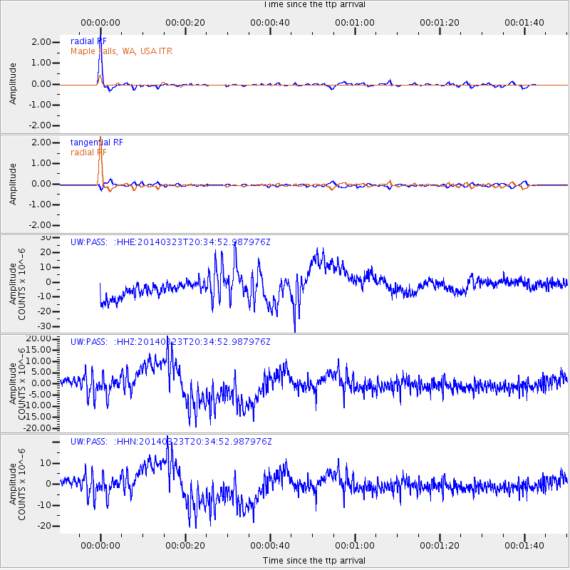
Signal To Noise
| Channel | StoN | STA | LTA |
| UW:PASS: :HHZ:20140323T20:34:52.987976Z | 2.3193588 | 3.618962E-6 | 1.5603288E-6 |
| UW:PASS: :HHN:20140323T20:34:52.987976Z | 2.2932255 | 3.8373755E-6 | 1.6733529E-6 |
| UW:PASS: :HHE:20140323T20:34:52.987976Z | 2.5309422 | 1.1771841E-5 | 4.6511695E-6 |
| Arrivals |
| Ps | 6.0 SECOND |
| PpPs | 24 SECOND |
| PsPs/PpSs | 30 SECOND |


