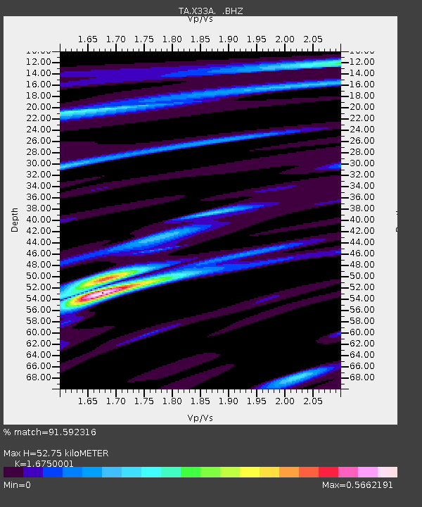
X33A Lawton, OK, USA - Earthquake Result Viewer
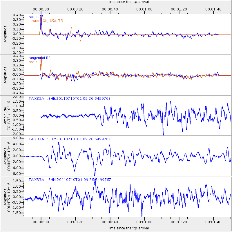
Earthquake location: Off East Coast Of Honshu, Japan
Earthquake latitude/longitude: 38.0/143.3
Earthquake time(UTC): 2011/07/10 (191) 00:57:10 GMT
Earthquake Depth: 23 km
Earthquake Magnitude: 6.6 MB, 7.0 MS, 7.0 MW, 7.0 MW
Earthquake Catalog/Contributor: WHDF/NEIC
Network: TA USArray Transportable Network (new EarthScope stations)
Station: X33A Lawton, OK, USA
Lat/Lon: 34.54 N/98.50 W
Elevation: 346 m
Distance: 87.8 deg
Az: 46.702 deg
Baz: 315.878 deg
Ray Param: 0.0430175
Estimated Moho Depth: 52.75 km
Estimated Crust Vp/Vs: 1.68
Assumed Crust Vp: 6.315 km/s
Estimated Crust Vs: 3.77 km/s
Estimated Crust Poisson's Ratio: 0.22
Radial Match: 91.592316 %
Radial Bump: 400
Transverse Match: 75.23666 %
Transverse Bump: 400
SOD ConfigId: 395004
Insert Time: 2011-12-16 06:31:56.674 +0000
GWidth: 2.5
Max Bumps: 400
Tol: 0.001

Signal To Noise

ChannelStoNSTALTA
TA:X33A: :BHZ:20110710T01:09:26.649976Z12.5841959.15928E-77.2784E-8
TA:X33A: :BHN:20110710T01:09:26.649976Z2.1340252.4357757E-71.1413998E-7
TA:X33A: :BHE:20110710T01:09:26.649976Z2.28393531.9132806E-78.377122E-8
Arrivals
Ps5.8 SECOND
PpPs22 SECOND
PsPs/PpSs28 SECOND