You are here: Home > Network List > TA - USArray Transportable Network (new EarthScope stations) Stations List
> Station U33A Lingo Farm, Meno, OK, USA > Earthquake Result Viewer
U33A Lingo Farm, Meno, OK, USA - Earthquake Result Viewer
| Earthquake location: |
Off East Coast Of Honshu, Japan |
| Earthquake latitude/longitude: |
38.0/143.3 |
| Earthquake time(UTC): |
2011/07/10 (191) 00:57:10 GMT |
| Earthquake Depth: |
23 km |
| Earthquake Magnitude: |
6.6 MB, 7.0 MS, 7.0 MW, 7.0 MW |
| Earthquake Catalog/Contributor: |
WHDF/NEIC |
|
| Network: |
TA USArray Transportable Network (new EarthScope stations) |
| Station: |
U33A Lingo Farm, Meno, OK, USA |
| Lat/Lon: |
36.43 N/98.11 W |
| Elevation: |
393 m |
|
| Distance: |
86.7 deg |
| Az: |
45.161 deg |
| Baz: |
316.028 deg |
| Ray Param: |
0.04384514 |
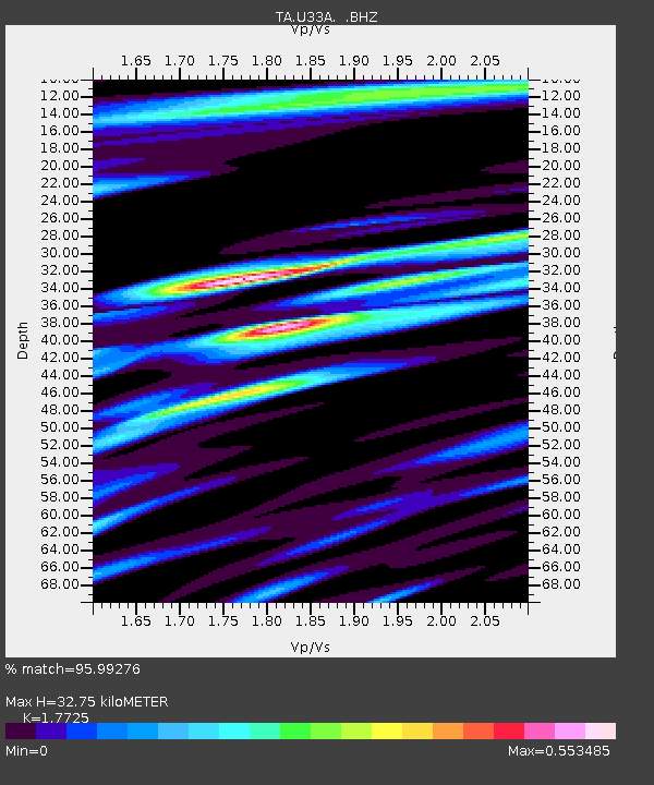
| Estimated Moho Depth: |
32.75 km |
| Estimated Crust Vp/Vs: |
1.77 |
| Assumed Crust Vp: |
6.426 km/s |
| Estimated Crust Vs: |
3.625 km/s |
| Estimated Crust Poisson's Ratio: |
0.27 |
|
| Radial Match: |
95.99276 % |
| Radial Bump: |
316 |
| Transverse Match: |
88.60767 % |
| Transverse Bump: |
400 |
| SOD ConfigId: |
395004 |
| Insert Time: |
2011-12-16 06:32:12.300 +0000 |
| GWidth: |
2.5 |
| Max Bumps: |
400 |
| Tol: |
0.001 |
|
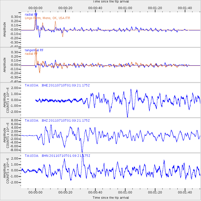
Signal To Noise
| Channel | StoN | STA | LTA |
| TA:U33A: :BHZ:20110710T01:09:21.175Z | 11.85272 | 1.150414E-6 | 9.705908E-8 |
| TA:U33A: :BHN:20110710T01:09:21.175Z | 1.400459 | 2.0590807E-7 | 1.4702897E-7 |
| TA:U33A: :BHE:20110710T01:09:21.175Z | 2.38268 | 2.800205E-7 | 1.1752333E-7 |
| Arrivals |
| Ps | 4.0 SECOND |
| PpPs | 14 SECOND |
| PsPs/PpSs | 18 SECOND |


