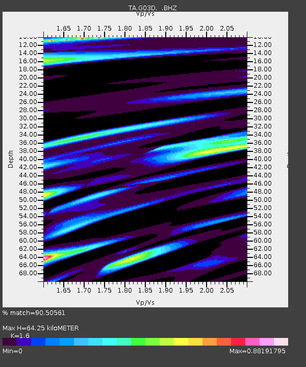
G03D McMinnville, OR, USA - Earthquake Result Viewer
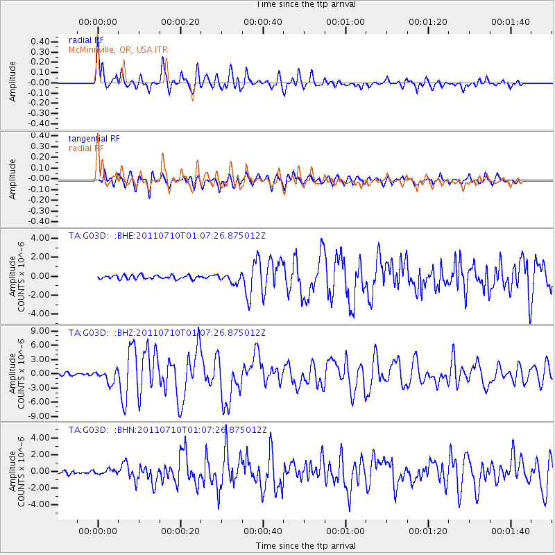
Earthquake location: Off East Coast Of Honshu, Japan
Earthquake latitude/longitude: 38.0/143.3
Earthquake time(UTC): 2011/07/10 (191) 00:57:10 GMT
Earthquake Depth: 23 km
Earthquake Magnitude: 6.6 MB, 7.0 MS, 7.0 MW, 7.0 MW
Earthquake Catalog/Contributor: WHDF/NEIC
Network: TA USArray Transportable Network (new EarthScope stations)
Station: G03D McMinnville, OR, USA
Lat/Lon: 45.21 N/123.26 W
Elevation: 222 m
Distance: 66.4 deg
Az: 50.346 deg
Baz: 300.675 deg
Ray Param: 0.057606786
Estimated Moho Depth: 64.25 km
Estimated Crust Vp/Vs: 1.60
Assumed Crust Vp: 6.566 km/s
Estimated Crust Vs: 4.104 km/s
Estimated Crust Poisson's Ratio: 0.18
Radial Match: 90.50561 %
Radial Bump: 400
Transverse Match: 78.55483 %
Transverse Bump: 400
SOD ConfigId: 395004
Insert Time: 2011-12-16 06:32:12.925 +0000
GWidth: 2.5
Max Bumps: 400
Tol: 0.001

Signal To Noise

ChannelStoNSTALTA
TA:G03D: :BHZ:20110710T01:07:26.875012Z6.5566021.3602466E-62.0746214E-7
TA:G03D: :BHN:20110710T01:07:26.875012Z1.40278982.5891214E-71.8456944E-7
TA:G03D: :BHE:20110710T01:07:26.875012Z2.56589914.7925613E-71.8677902E-7
Arrivals
Ps6.2 SECOND
PpPs24 SECOND
PsPs/PpSs30 SECOND